 Welcome to Death Valley National Park, at over 3 million acres, it's the largest national park in the lower 48 states. It's a place full of colorful geology, unexplained phenomenon, extreme variations, and wonderful surprises.
On today's trip, I'm going to take you from the southeast end of the park, near Shoshone, along the road that traverses the eastern side of the park up to Scotty's Castle.
 Spring is a great time to visit Death Valley. Not only are the temperatures reasonable, but desert plants brighten the landscape. Some of the best places to see flowers are right next to the roads. Just park and wander around, and the diversity of life becomes apparent.
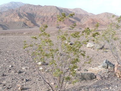 One of my favorite plants, the creosote bush (Larrea tridentata) was in bloom.
 The bright yellow flowers flashed as the branches waved in the wind.
 Spring is a popular time to visit Death Valley, and in fact there were thousands of people staying at Furnace Creek, the park headquarters area. But because Death Valley is so huge, people are spread out in the rest of the park, and it often felt like I had it all to myself.
 It was easy to pull off the highway and snap photos of whatever caught my attention, like some more wildflowers and the beginning of a salt flat.
 The salt makes it hard for vegetation to live, but nevertheless, some plants and animals have adapted to it. One of the reasons there is so much salt in the bottom of Death Valley is that it used to have a huge lake in it, Lake Manly. When the water evaporated, the salt was left behind. The lake fluctuated at different levels, so there were many opportunities for salt to be deposited.
 As I headed north, I noticed some people walking out on a big salt flat. I rounded a curve and saw a parking area. This wasn't just any salt flat, it was...
 ...Badwater! The lowest spot in North America, at 282 feet below sea level. A boardwalk stretched out from the parking lot onto the salt flat.
 I was there late in the day, but I could just imagine the heat of a July sun at noon. It would probably be over 120 degrees Fahrenheit, about hot enough to start drying a person into jerky.
 These holes intrigued me. I'm not sure what caused them, but it makes me wonder if there are parts of Badwater that might suddenly sink and swallow me up.
 Off the beaten path, the salt deposits rise up and provide interesting relief.
 At Devil's Golf Course, the salt formations are even higher. They look delicate, but most are very hard and crunchy. Footing is difficult, and a fall would hurt.
 Since it was late in the day, for a short while I was the only one out there, and it felt both neat and creepy at the same time.
 I decided to take a detour off the highway to go on Artist Drive. The mountains are particularly colorful in this area. With the sun mostly behind Telescope Peak and the other mountains on the other side of the valley, I didn't have the full effect of the artist's palette, but it was still spectacular. The road is one way because of some tight turns and constricted canyons. Maybe next time I can do it on bicycle.
 The next day I got a really early start and continued further north to Salt Creek. This is a little creek on the valley bottom. Despite the high salt, high temperatures, and scarce vegetation, this creek manages to be home to tiny pupfish, along with aquatic insects, birds, and more.
 A sand dune with pickleweed is right near the trail. The pickleweed is succulent, with squishy flesh that stores water.
 To protect the creek, the trail is on a boardwalk which goes next to and sometimes over the creek.
 Further north I found more good places to stop and enjoy the wildflowers.
 It was a very windy day, so I decided to skip the sand dunes near Stovepipe Wells. In the distance of this photo you can see the sand blowing off the dunes. If you want to experience a sand storm, one way to get a similar feeling is go to sand dunes on a windy day. I'm not sure why you would want to experience a sand storm, but just in case...
 There is just so much to see in Death Valley that at times it becomes visually overwhelming. One thing I like to focus on are the alluvial fans, the land flowing out of the canyons in a fan-like pattern. Water eroded the rock away further upstream, redepositing it. As I look at the alluvial fan, my eye always moves up to the mouth of the canyon and I wonder what is up there. Death Valley must have hundreds of alluvial fans, so it makes my imagination go wild.
 Another stop to admire some beautiful phacelia. Flowers bloom at the lower elevations from about February to the end of March, and then they start blooming at higher elevations. Telescope Peak is over 11,000 feet high, so there are even flowers blooming in the middle of summer in Death Valley.
 A couple more alluvial fans coming down from mountains on the other side of the valley, with creosote bushes in the foreground.
 Towards the north end of Death Valley, the main road curves to the east and goes to Scotty's Castle.
 The area is an oasis, and it's fun to wander the grounds and feel a little more humidity. A hummingbird was hanging out near the small waterfall between these palm trees.
 Continuing up Grapevine Canyon, the road eventually leaves the park. I like the back of the park entrance sign, which said "Thanks for Experiencing Your National Park. Please Visit Again."
 Spring is a great time to visit Death Valley. Not only are the temperatures reasonable, but desert plants brighten the landscape. Some of the best places to see flowers are right next to the roads. Just park and wander around, and the diversity of life becomes apparent.
 One of my favorite plants, the creosote bush (Larrea tridentata) was in bloom.
  The bright yellow flowers flashed as the branches waved in the wind.
  Spring is a popular time to visit Death Valley, and in fact there were thousands of people staying at Furnace Creek, the park headquarters area. But because Death Valley is so huge, people are spread out in the rest of the park, and it often felt like I had it all to myself.
 It was easy to pull off the highway and snap photos of whatever caught my attention, like some more wildflowers and the beginning of a salt flat.
 The salt makes it hard for vegetation to live, but nevertheless, some plants and animals have adapted to it. One of the reasons there is so much salt in the bottom of Death Valley is that it used to have a huge lake in it, Lake Manly. When the water evaporated, the salt was left behind. The lake fluctuated at different levels, so there were many opportunities for salt to be deposited.
 As I headed north, I noticed some people walking out on a big salt flat. I rounded a curve and saw a parking area. This wasn't just any salt flat, it was...
 ...Badwater! The lowest spot in North America, at 282 feet below sea level. A boardwalk stretched out from the parking lot onto the salt flat.
  I was there late in the day, but I could just imagine the heat of a July sun at noon. It would probably be over 120 degrees Fahrenheit, about hot enough to start drying a person into jerky.
 These holes intrigued me. I'm not sure what caused them, but it makes me wonder if there are parts of Badwater that might suddenly sink and swallow me up.
 Off the beaten path, the salt deposits rise up and provide interesting relief.
 At Devil's Golf Course, the salt formations are even higher. They look delicate, but most are very hard and crunchy. Footing is difficult, and a fall would hurt.
 Since it was late in the day, for a short while I was the only one out there, and it felt both neat and creepy at the same time.
 I decided to take a detour off the highway to go on Artist Drive. The mountains are particularly colorful in this area. With the sun mostly behind Telescope Peak and the other mountains on the other side of the valley, I didn't have the full effect of the artist's palette, but it was still spectacular. The road is one way because of some tight turns and constricted canyons. Maybe next time I can do it on bicycle.
 The next day I got a really early start and continued further north to Salt Creek. This is a little creek on the valley bottom. Despite the high salt, high temperatures, and scarce vegetation, this creek manages to be home to tiny pupfish, along with aquatic insects, birds, and more.
  A sand dune with pickleweed is right near the trail. The pickleweed is succulent, with squishy flesh that stores water.
 To protect the creek, the trail is on a boardwalk which goes next to and sometimes over the creek.
 Further north I found more good places to stop and enjoy the wildflowers.
 It was a very windy day, so I decided to skip the sand dunes near Stovepipe Wells. In the distance of this photo you can see the sand blowing off the dunes. If you want to experience a sand storm, one way to get a similar feeling is go to sand dunes on a windy day. I'm not sure why you would want to experience a sand storm, but just in case...
 There is just so much to see in Death Valley that at times it becomes visually overwhelming. One thing I like to focus on are the alluvial fans, the land flowing out of the canyons in a fan-like pattern. Water eroded the rock away further upstream, redepositing it. As I look at the alluvial fan, my eye always moves up to the mouth of the canyon and I wonder what is up there. Death Valley must have hundreds of alluvial fans, so it makes my imagination go wild.
 Another stop to admire some beautiful phacelia. Flowers bloom at the lower elevations from about February to the end of March, and then they start blooming at higher elevations. Telescope Peak is over 11,000 feet high, so there are even flowers blooming in the middle of summer in Death Valley.
 A couple more alluvial fans coming down from mountains on the other side of the valley, with creosote bushes in the foreground.
 Towards the north end of Death Valley, the main road curves to the east and goes to Scotty's Castle.
  The area is an oasis, and it's fun to wander the grounds and feel a little more humidity. A hummingbird was hanging out near the small waterfall between these palm trees.
 Continuing up Grapevine Canyon, the road eventually leaves the park. I like the back of the park entrance sign, which said "Thanks for Experiencing Your National Park. Please Visit Again."


2 comments:
Another beautiful place that is calling my name.
Wow, that post brought back memories. Loved the dates that had ripened and dropped on the ground from the date palms at Furnace Springs. I remember quaffing an adult beverage while snacking on them after dark as my brother and I conversed on a picnic table. We were camping and earlier in the day had experienced one of the few storms that Death Valley has.
Pedro
Post a Comment