Wednesday, August 29, 2018

Sledding at the Rock Glacier and Swimming in Brown Lake

 My friend Jenny had some visiting nieces, and I had a day I could take off work, so it was time for two moms and eight kids to head out for a hike. We've done most of the hikes in the area, so we wanted a way to get the kids excited. So we decided to go sledding at the rock glacier and swimming in Brown Lake.

That was enough to get them hiking. And then they were happily talking to each other, and the miles passed quickly.

I pointed out some SPLAT verbenone that had been applied to a limber pine. This synthetic pheromone mimics the scent that mountain pine beetles give off when they have invaded the bark of the tree and the bark is full. Basically it tells the incoming beetles to pick a different tree. This tree is being protected because seeds from it are being tested to see if they are resistant to white pine blister rust, a non-native pathogen. If they are resistant, then this tree could help start many more trees that are resistant.

We had some fun poses as we got up to the bristlecones.

I love the beautiful colors and lines of their wood.

Even the roots are amazing. And roots are often exposed because they've been there thousands of years, and the surrounding soil has eroded away.

We didn't stay in the bristlecones long, though. We continued up into Wheeler cirque to see the rock glacier.

I had to pause to admire some beautiful wildflowers. The pink ones are in the saxifrage family, white-daisy ones are Erigeron leiomerus, and the white matted ones are Phlox pulvinata.


And then we were there! On the east side of the rock glacier, we found some nice snow patches. It turned out to be slipperier than we expected. 

Which made it good for sledding! Even Jenny and I gave it a try.

We found garbage bags and backpacks were good items to slide on.

We kept at it for quite awhile.

Eventually, though, we headed back down the trail. You can see Brown Lake from the trail, but there's not a trail to it, so we had to step carefully on the moraine, which has lots of big boulders that like to move.

Eventually we got to the lake. It's obviously brown in color.  It's also not very deep. I walked all over it and found the deepest spot to about 1 meter (3 feet).

Even though it's not deep, it sure has a scenic background!

The water was quite pleasant in temperature, but the rocks in the lake were covered with algae and very slippery. We found it was better to crawl around than risk falling.

Eventually it was time to get out.

The hike back was easy, and we even managed to bring back all the kids!
Jenny was much better about posting this hike on her blog in a timely manner. Oh well, I guess better late than never!

Friday, August 24, 2018

Floating the Sevier River-Leamington Canyon Utah

One day in June, our friends Andy and Bonny asked if we'd like to go kayaking the Sevier River through Lemington Canyon with them. That had been on our bucket list and we had nothing going on that Sunday, so we said yes! Then we had to figure out what we were getting into! It turns out there isn't much information about floating/rafting/kayaking the Sevier River. We were able to find a little information, and it suggested that the river, at 385 cfs, might be a little low, since the website recommended a minimum of 500 cfs for kayaking. I checked with someone from Leamington, and he said that locals usually tube the river on Fourth of July and he thought we'd be okay, so off we went. We met our friends at the put-in, near the railroad tracks in Leamington Canyon, and stationed another vehicle in the town of Leamington.

The river started off mellow. Andy and Bonny had nice inflatable kayaks.

Meanwhile, we brought a menagerie of boats. A kids' hard-sided kayak, an inflatable kayak, a SUP, and an inner tube for just-in-case. We figured that since a highway was nearby, if we ran into trouble we could always get out and hike over to the highway.

We quickly figured out that the inner tube was very hard to steer, so we ended up dragging that along. That meant one person (usually Desert Girl) doubled up either on the paddle board or inflatable kayak.

Eventually the mellow section ended. We pulled over to shore to investigate the loud, roaring noise ahead of us.

This was the first diversion dam. It was quite impressive.

Downstream was quite rocky, beyond our family's ability, but Andy and Bonny were able to negotiate it just fine.

Here was our portage, with a couple trips for my husband and me. It wasn't too long.

Then we were back into the water, this time moving faster.

Eventually we came to another dam, this one made of boulders. Here's Bonny easily negotiating it. (Our family also portaged this one!)

Downstream was quite exciting, with lots of white water. Desert Boy loved it.

But you couldn't go too fast, as a barbed wire fence crossed the river! Andy stopped and held it up for us. This was just the first of many more (I think about eight). We never knew when they'd be coming.

Once in awhile we could see more from the river, like the Leamington Canyon cement facility.

At a third diversion dam, a rancher warned us about the upcoming barbed wire under a trestle. It turned out to be at the second trestle down, and it was easy to miss, just out of the water a couple inches.

Navigating yet another barbed wire fence. I'm not sure how the kayakers do this at higher flows--some of the places it was hard to go under or over and if the water was moving faster, you might have a hard time getting out if needed.

Can you spot this one?

The river mellowed out and had lots more big turns. Still plenty of barbed wire fences.

It took us about 6.5 hours to negotiate 10 miles of river. It was a fun trip, and I'd do it again. (My husband probably wouldn't, he found it got a bit tedious after awhile--maybe partly because Desert Girl took a two-hour nap slumped against him in the kayak!)

Here's a view from Google Earth of our route. I couldn't find all the fences on Google Earth--there are many more than shown!

Friday, August 17, 2018

Trail Run up Hendry's Creek, Nevada

The kids went to 4-H camp for a weekend, which meant I had a free Saturday. Wow, what was I going to do? I felt a little delirious with free time! I decided to do something I like to do but they don't: a long trail run. I wanted to take the dog, which meant the trails in Great Basin National Park were out. So I went up to the North Snake Range to Humboldt-Toiyabe National Forest to Hendry's Creek. There were lots of geology student tents along the way, but I didn't see anybody.

Not far from the trailhead I passed a huge patch of poison ivy. This is one of the few places in the area where it grows (also in Big Wash/Hidden Canyon and farther north around the Deep Creeks). I don't remember so much being along the trail like this, so I think it's spreading. :(

But then the trail goes into the uplands and all is good. I didn't know how far I was going to go, but I figured the high chance of rain might help turn me around. The trail is about 10 miles long to get to the amazing Table, a high elevation plateau near Mt. Moriah. I figured I wouldn't go that far today, but the thought lingered in my mind.

At mile 1.5 I entered Mount Moriah Wilderness Area. It doesn't really look much different!

There are lots of creek crossings. In early June, at high water, they can be dangerous. But in mid-July, I didn't even have to get wet.

It was cool getting to areas with big ponderosa pines. The dog did well, despite having broken her femur a few months ago and having surgery. We've been going on shorter runs to get her back in shape. And quite frankly, a lot of the uphill section of this "run" was fast walking. This photo was about mile 3.

This humongous ponderosa pine was about mile 4. I had turned on the "Map My Run" app on my phone so got an update every mile.

A cool flower, Scouler's St. John's Wort (Hypericum scoulei), that I don't see often.

At mile 5 I saw bristlecones (Pinus longaeva) ! Wow. These lower-elevation bristlecones don't live as long as the ones up on the high ridges.

Just a bit beyond was a nice campsite in the aspens.

And at this eighth stream crossing, a bit beyond 5 miles up the trail, I decided I would take a break and turn around. It felt so good to take off my shoes and put my feet in the cold water. I saw Bonneville cutthroat trout in the water.

I also enjoyed the fireweed, a pretty flower that grows in disturbed places. I remember it well from when I worked in Glacier Bay in Alaska.

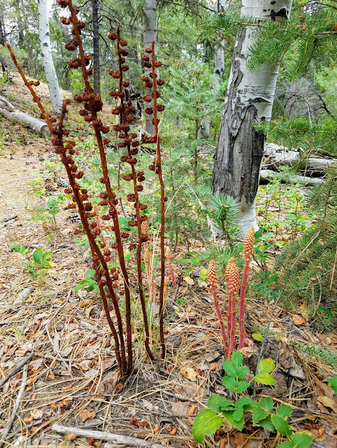
I also enjoyed these Pinedrops, non-vascular plants with no chlorophyll.

Bowing to the millennial craze, I took a selfie showing some of the trail.

How cool, orchids! Streamside orchid-Epipactis gigantea. You don't expect them in the high desert, but they can hide out in riparian areas.

It was a lovely trail run, and even though I wasn't super fast, I had a great time checking out my surroundings and just being out in the wilds. My spirit felt renewed from this jaunt. And how great is it to still have places where you can hike/run and see no one!
Related Posts Plugin for WordPress, Blogger...

blogger templates