Showing posts with label geology. Show all posts

Monday, February 15, 2021

Checking Out Lunar Crater, Nevada

We were heading across Nevada on Highway 6, and 75 miles east of Tonopah (near Nye County mile marker 79) made a turn. We took a detour to Lunar Crater, nine miles off the highway on a gravel road. Part of the Lunar Crater National Natural Landmark (designated in 1973), Lunar Crater is a 430-foot deep maar, or volcanic explosion pit.

With several hours of driving ahead of us, I proposed that we get our blood flowing and hike down to the bottom. My husband agreed and the kids had no choice.

We were the only ones there, which didn't surprise us. Highway 6 is one of the least traveled highways in the U.S., so we didn't even see many cars on the highway. The crater looked beautiful. I figured there was a way down, but wasn't sure what the route was.

Fortunately it wasn't too bad, although getting down the cliff band takes a little scrambling. 

In 1972, astronauts practiced picking up rock samples here in full spacesuits. It was part of NASA's program to get the Apollo 16 and 17 astronauts more familiar with volcanic features.

In short time we were down at the bottom.

Desert Boy was even willing to smile!

Over in the corner was an intriguing looking canyon. 

I was fascinated by the buckwheat, a reddish plant growing on the volcanic soil. It would be much prettier in the summer!

Then it was time to start back up!

It was cool seeing the lava swirl by the cliff band.

There are over 20 volcanic features visible from Lunar Crater. Can you spot the one in the background?

From the top was a nice view of Easy Chair Crater to the northeast.

There's a short trail and a bench by the Lunar Crater parking area.

A little plaque under the bench.

Apparently you can make a backcountry loop past Lunar Crater on a scenic byway to get back on the highway. We didn't know, so we went back to the highway the same way we came, seeing a few cows.

We had another nice view of Easy Chair Crater.

Off in the distance, on the other side of the highway, we could see the Black Rock Lava Flow. I've done a previous post about it, and it's another fun stop. Here's more about the geology from the Nevada Bureau of Mines and Geology.

Looking at this area from the birds-eye view is fascinating. The lava flow really stands out with its black. I like seeing the shapes of all the craters. And there are a surprising number of playas.

And here's a closeup:

If you like seeing some different things, I highly recommend visiting Lunar Crater.

Before I end, let me pose a question. Where do you see big craters?
1. Volcanic areas
2. Meteors (e.g., Meteor Crater in Arizona)

Do you have a favorite crater?

Monday, June 15, 2020

What to Do at Great Basin National Park during Covid-19

Wheeler Peak and Doso Doyabi at Sunset, as seen from the Scenic Drive

The status of Great Basin National Park is changing frequently. For the most up-to-date information, see the Park website.

This blog post is intended to help those trying to figure out what to do during a park visit, especially since the visitor centers are currently closed. As of June 15, 2020:
  • The roads and trails and most campgrounds are open except
    • Wheeler Peak Scenic Drive Will be closed from June 29 through July 2nd 
    • Update: on 7/1, the park announced the Drive will also be closed July 7-10
  • The only paved road in the park is to the Lehman Caves Visitor Center and the Wheeler Peak Scenic Drive.
  • Wheeler Peak Campground will not open this summer, as it is being renovated.
  • Great Basin Visitor Center will open soon, possibly June 26.
  • Lehman Caves Visitor Center and Lehman Caves are likely to be closed for the summer. It's a little ironic, as the Lehman Caves Visitor Center got new, cool interactive exhibits in February. Want to see the cave? Here's a short video that shows more about caves and cave research in the Park.
    Short video about Cave Research in the Park
1. Where to stay?
If you're camping, you have lots of options. Camping in the park for tents and small RVs is available in Lower Lehman (best spots for RVs), Upper Lehman (spacious campsites), Baker Creek (often last campground to fill), Grey Cliffs (only 1.5 miles from main road, but not much shade), and Snake Creek (dispersed and no potable water, but free). Campsites often fill by 2 pm on weekdays, earlier on weekends. (Where to camp if the park campgrounds are full.) No hook ups in the park. If you have a big RV (longer than 24-30 feet), the park campsites probably won't accommodate you, but the Whispering Elms in Baker has beautiful sites, and there are also RV sites at the Border Inn and Baker Fuel and RV. A variety of motel and Air B&B options are available at discovergreatbasin.com. Some folks will also stay in Ely, Delta, or Milford and come for a day trip.
Camping under the Milky Way

Where to eat?
Bring your own food or enjoy eating out. Right now, here's what's open (with more details at discovergreatbasin.com):
  • Border Inn, on Highway 6 & 50 at stateline, kitchen open daily from 6 am to 10 pm (breakfast, lunch, dinner)
  • Great Basin Cafe, next to Lehman Caves Visitor Center, daily from 8 am to 5 pm (breakfast, lunch)
  • Baker Bean Coffee Cart, downtown Baker, daily from 7 am to 3 pm (breakfast, lunch, coffee and baked goods)
  • Kerouac's, downtown Baker, 4 pm to 8 pm (dinner), closed Tuesdays and Wednesdays
Convenience stores are also located at the Border Inn, Kerouac's, and Great Basin Cafe.

What to do?
1. Ancient bristlecones. If you've never seen old bristlecone pines, old meaning more than 3,000 years old, this is your chance. Drive 12 miles up the Wheeler Peak Scenic Drive to the end of the road at the Bristlecone trailhead. Then plan for about an hour-long hike over a rocky trail at over 10,000 feet elevation to an amazing grove in the shadow of Wheeler Peak. Allow 30 minutes for the drive each way, plus 2-3 hours for the hike. You can hike beyond the grove to the rock glacier, add 0.5-2 hours depending on how far you go. Note that the parking area is starting to fill from about 10 am to 3 pm, so consider earlier or later, when the light is better and parking more abundant.
Hike to Wheeler cirque bristlecone grove in Great Basin National Park
Wheeler cirque rock glacier at 10,800 feet. There is still ice under the rocky shroud, at least in the upper portions of the rock glacier. A tiny real glacier is found along the headwall.

2. Cool off at higher elevations. Also at the end of the Scenic Drive is the Alpine Lakes Loop. This is a charming two-hour hike that visits Teresa and Stella Lakes. Take your time and soak in the cooler temperatures. Watch out for afternoon thunderstorms, high winds, and elevation sickness. The reward is amazing views. You can combine this with the bristlecone pine hike for a lovely longer hike.
Stella Lake at sunrise

3. Beautiful hikes. Great Basin National Park is a hiking park. The two trails mentioned above are relatively busy, but most of the others don't have much traffic!

3a. Short trails (approx. 30 minutes to 1 hour):
  • Mountain View Nature Trail behind Lehman Caves Visitor Center--through pinyon/juniper forest for 1/4 mile;
  • Sky Islands Forest Trail-Accessible trail at Bristlecone trailhead--through Engelmann spruce/limber pine forest for 1/4 mile, wheelchair accessible
  • Strawberry Sagebrush Loop Trail: 1+ mile loop that lets you look at how the landscape is recovering after the 2016 Strawberry fire
  • Start any of these other trails listed below and turn around when you want
3b. Medium trails (2-4 hours)
  • South Fork Baker/Baker Lake loop: 3.5 mile loop, steep in places, but gorgeous, follows riparian areas
  • Serviceberry Trail: 3+ mile loop along Snake Creek road with a variety of habitats
  • Lexington Arch: 6+ mile round-trip hike to a huge natural bridge; dogs allowed (here's more about the canyon)
  • Osceola Ditch Trail: 1.5 miles to Mill Creek, 5 miles to Strawberry Creek trailhead, steep for first 0.3 mile, then the the flattest trail in the park, follows old water ditch and goes through 2016 burn
  • Bristlecone/Alpine Loops trails mentioned above

3c. Long trails (>3 hours)
  • South Fork Baker/Timber Creek loop: 5.5 miles but lots of elevation change, two beautiful meadows
  • Dead Lake: a new trail from the end of the Snake Creek road heads to this often-overlooked lake, and you can make a loop trail of it
  • Wheeler Peak summit: the trail is 4-miles one way, but gains 3,000 feet elevation. Many people underestimate the effort it will take. Plan on 3-4 hours to summit, some time at the top, and 2-3 hours to get back down. Take plenty of water and food and be prepared for big winds. Stay off if storms are looming.
  • Shoshone/North Fork Big Wash: If you want a trail to yourself, start at the end of the Snake Creek Road and head up and over into the next drainage. Seldom visited, some bushwhacking required.

4. Backpacking.
  • Baker/Johnson loop: this is a classic. Start at the Baker Creek or Snake Creek trailheads. About 13 miles round trip with lots of elevation change. Camp at Baker or Johnson Lakes. No campfires above 10,000 feet.
  • South Fork Baker/Timber Creek loop: This loop is only about 5.5 miles, but lots of elevation change. Good for beginning backpackers and families.
  • Johnson Lake/Snake Ridge Divide loop: This is for the advanced, as you have to scramble along a ridge with no trail.

5. Animal Watching.
  • Yellow-bellied marmots. From May to about July, it's often possible to find yellow-bellied marmots along the Baker Creek road. You'll see the marmot crossing signs--these cute animals aren't the smartest, so slow down to keep them safe!
  • Rocky mountain elk are seen most frequently in the Strawberry Creek drainage. They are much larger than deer.
  • Bird-watching is excellent along Strawberry Creek, where you can find lots of cavity nesters like mountain bluebirds, hairy woodpeckers, house wrens, and mountain chickadees. Baker Creek area has lots of riparian birds like warbling vireos, MacGillivray's warblers, yellow warblers, lazuli buntings, and more.
  • Fishing. With a state permit, fishing is allowed in the park. Native Bonneville cutthroat trout are in South Fork Baker, Snake, and Mill creeks (catch-and-release recommended as the Park is trying to restore these populations). Brown, rainbow, and brook are in Baker and Lehman Creeks.

6. Check out the Dark Night Skies. If you're camping, your campsite might be a great place. Another recommended place is Mather Overlook. You will see the Milky Way best during and near the New Moon (in 2020: June 21, July 20, Aug 19, Sept 17, Oct 16).
Milky Way from Mather Overlook


7. Other Nearby Places Worth Visiting

Baker Archeological Site - visit the townsite of a Fremont village, occupied from 1220 to 1295. It's about 2 miles from Baker, and a guided booklet tells you about the site and how the buildings were arranged. This is a good place to picnic, with covered picnic tables.
    • Baker Archeological site

    Sacramento Pass Recreational Area
    : Camping, fishing, plus mountain biking and hiking on a seven-mile trail system. Only 15 minutes from Baker.
      Sac Pass fishing pond
Crystal Ball Cave: Although Lehman Caves isn't open, Crystal Ball Cave, 30 miles north of the Border Inn, is open by reservation only. This is a terrific cave, it feels like walking through a giant geode. It also is the site of amazing paleontological resources. Cave website (keep in mind that it's located in mountain time zone and takes about 45-60 minutes to get there from Baker)

Crystal Peak is a cool volcanic mountain located about an hour from Baker. You can see it gleaming in the afternoon sunlight from Highway 6 and 50, and also from high points along the Scenic Drive.


Those are just a few suggestions, click on the links to see additional information. If you'd like more, Read my book! It is full of natural and cultural history of the area, places to visit, and more.

Saturday, May 30, 2020

Quick Trip to Crystal Peak, Millard County

With distant trips cancelled, it was time to head to nearby attractions. One of my favorite places to go when the weather is mild is Crystal Peak, a whitish mountain made of volcanic tuff. In the afternoon light it glows when approaching from Snake Valley, but on this particular day, we were heading there in the morning, and it didn't look that impressive as we approached it.

 As we got closer we saw a sign indicating that the peak is in part of the Wah Wah Wilderness Study Area. Wah Wah means "good, clean water" according to Utah Place Names. A Wilderness Study Area (WSA) is an area that is wild, uninhabited, retains primeval characteristics, is a roadless area of at least 5,000 acres, and has opportunities for solitude and/or primitive recreation. WSAs are managed as wilderness areas (no motorized vehicles allowed, generally no development allowed) until Congress decides to designate the area as wilderness or not.

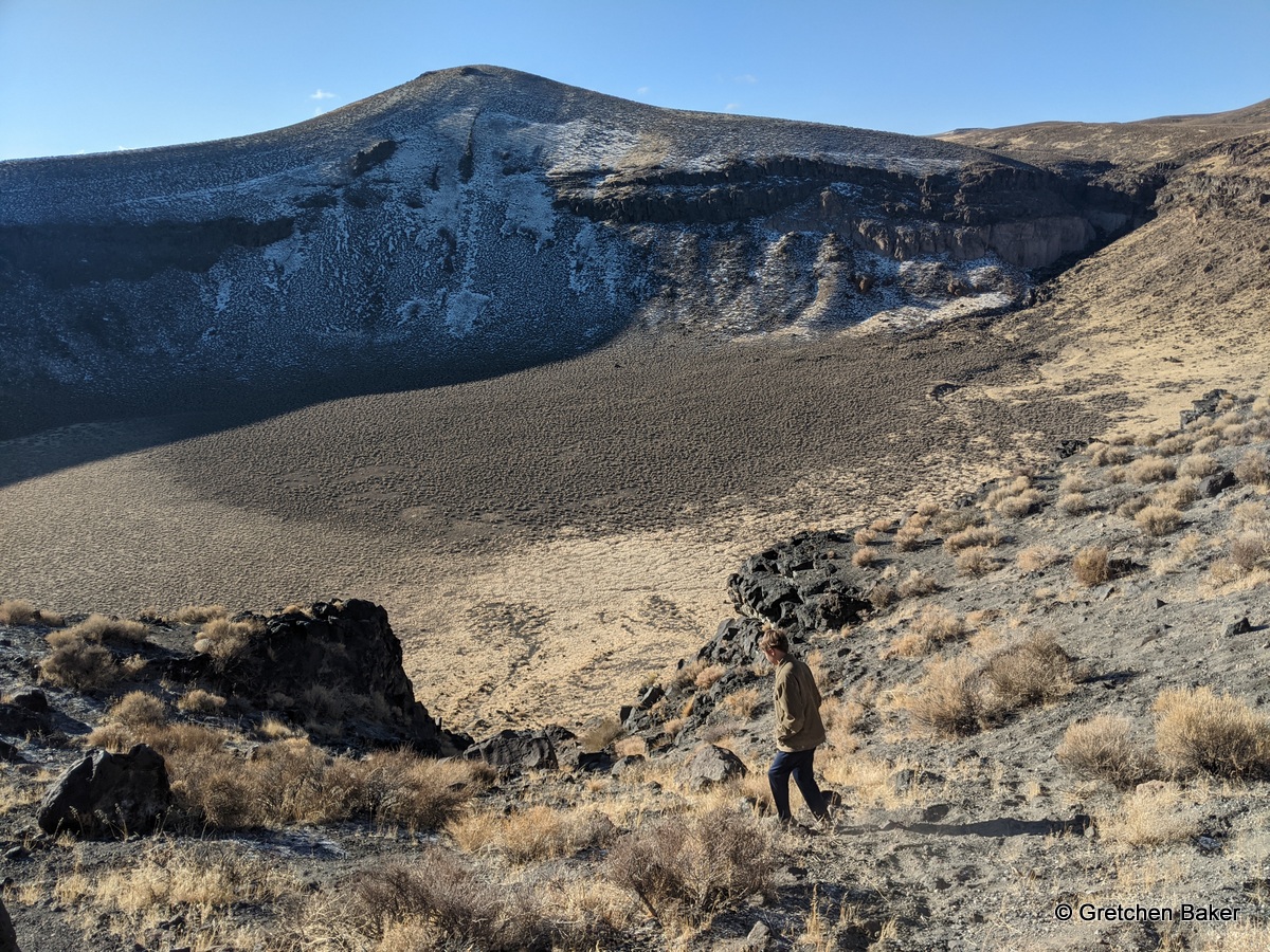
Desert Boy had been to the top of Crystal Peak before (see this 2014 trip), but Desert Girl hadn't.  We parked on the northeast side, just off the road in a little campsite. No other vehicles were visible. We hiked slightly towards the peak, but mostly south.

Although it's easiest to stay on the Kanosh Shale that borders the south side of the Tunnel Springs Tuff, we couldn't resist a little scrambling. The strange-looking pockets are called tafoni.

There are thousands of them on the mountain.

 We headed up the Kanosh shale, going around juniper trees until we reached a large rock cairn. Then it was time to head north.

In hindsight, we should have tied up the dogs at this spot, as they would have had shade, and it got a lot steeper after this point.

We needed to follow the ravine and then veer a bit to the right to make the summit. There are many false summits on this mountain, and I've been to more than one!

The kids did a good job hiking fast. 

The dogs made us laugh at times!

Here's the view looking south. You can see the little ridge where the tuff meets the Kanosh shale. In the background are the Wah Wah Mountains.

Looking to the west, we could see the snow-capped peaks of the Snake Range just peeking above the horizon.

We had a little detour, but then we made it! Hurray!

 Looking north from the peak you see the Crystal Peak Road. On the other side is the mountain range that contains Fossil Mountain.

Next it was time to get down. This isn't a good place to go if you're afraid of heights!

Desert Girl is quite interested in geology and found some fossils.

Many of the fossils in the Kanosh Shale are broken as it was a windy beach area as sea creatures accumulated, but there are still interesting things to find.

We made it back to the vehicle and didn't dally, as Desert Girl had something to attend. 

Except I did have to pause to take some photos of pronghorn. They are such cool desert creatures that I will be doing a post all about them soon.

The cloud pattern on Wheeler Peak and adjoining Doso Doyabi Peak was really cool.

And then we saw lambs! They were so cute!


This area is used for winter sheep grazing. In the summer they head to Park City, UT.

For more on the geology of Crystal Peak, and how it formed in a giant explosion 33 million years ago, was covered up, and then eroded away (plus how it will disappear in a million years), see this cool GeoSights post by the Utah Geological Society.
Related Posts Plugin for WordPress, Blogger...

blogger templates