A lot of my time over the past couple weeks has been spent on the Strawberry Fire, started in Great Basin National Park by a lightning strike. The fire is nearly over (we hope!), and I have a day off to download photos and reflect on what's happened.
The fire was reported on Monday, August 8 about 11 am. Some park staff looked at it and reported that it covered about 15 acres and spreading quickly. The BLM was called in to assist with full suppression. A few hours later, the fire had spread to an estimated 2,000+ acres. Fire crews weren't even able to enter the canyon because it was too dangerous.
We went out that evening and got some views. Watching the fire and smoke column was even better than watching TV!
I drove around to Highway 6/50, where ash was falling. I pulled off the road and found some vantage points of the glowing canyons.

With a long exposure I could see the many little fires on the hillside, each of them a glowing tree. It was a bit surreal.
From the Mill Creek road, I got a neat long exposure of the rising smoke. The light on the left is the moon. The light in the lower right is from flames.
That night, crews stayed on the ranch, and I stepped outside to see them do their 6 am briefing.
The smoke continued on Tuesday, with big patches of trees burning. It seemed like the fire was spreading in at least a couple directions.
After work, I picked up the kids and we took a little drive.
A sign on Highway 6/50 said Smoke Across Highway. They were certainly right.
We drove through the smoke and past Weaver Creek. I climbed a hill and got this perspective on the fire.
Then we went to Silver Creek Reservoir, which was being used by a dip site by one of the helicopters. It was cool to watch. We managed to swim a little in between helicopter trips, and that water is beautiful!
Here's the view from the Mill Creek side, with the private property in the lower left.
On Wednesday, I had an all-day hike for work. When I returned in the late afternoon, I cooled off in the pond near our house. I noticed that everything looked orange. The wind had changed, and the smoke was blowing across the sun. Fortunately, the fire didn't grow too much, but was estimated at over 3,000 acres.

Thursday was my first chance to go into Strawberry Creek Canyon and look at it with the eyes of a Resource Advisor from the fire. (My photos are elsewhere from that day, but you'll get an idea soon of what it looked like.) While approaching the canyon, we could see a nice mosaic of burned and unburned areas. I was hopeful the fire had burned similarly further up canyon. But once we entered the canyon, we saw that the fire had burned everything from ridgetop to ridgetop, including the entire riparian area. I groaned, thinking of the flash floods that would ensue. In fact, Facebook reminded me of a post the year earlier, when my supervisor and I had nearly been trapped in Lexington Canyon due to a flash flood over the Black Fire. We barely got out of there and thought we would surely have to spend a night, unprepared, in the canyon.
On Friday, 8/12, I returned to the fire as a Resource Advisor and accompanied another Resource Advisor who had come from Redwoods National Park. Our task for the morning was to assess a potential spike camp and helispot past the end of the road. We got some good views on our hike, including some burned areas near the top of Strawberry Creek.
We followed
the historic Osceola Ditch, which had burned over. The steep slopes adjacent to it will make preserving the ditch difficult.
The sign showing the Mountain Shrub Community will make a good photopoint as the vegetation returns to the landscape. You can see the many smokes in the Blue Canyon area of the fire.
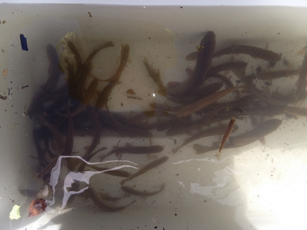
Some other folks were electrofishing Strawberry Creek that morning to see if any Bonneville cutthroat trout could be salvaged. To my great surprise, they found a lot of fish. Hurray! I was so happy to be wrong. They were moved to Silver Creek. More fish salvage is expected to take place next week, hopefully before it rains.
In the afternoon we witnessed several retardant drops, including some by VLATs--Very Large Air Tankers. Read
mucho dinero.

Saturday I left the fire in the hands of three very capable NPS resource advisors from other parks. The number of people on the fire had swelled to over 400, and acreage was now estimated at over 4,000 acres. I attended a workshop and dinner that I had signed up and paid for weeks earlier. It turned out I wasn't quite done with the fire for the day, though. During dinner I got a call asking me to respond to the fire in the ambulance, as there had been a fatality on the fire and the primary ambulance had gone to respond to it and they needed a backup ambulance. When I got to the fire camp, which had swelled to a dozen yurts and many semi-trailers, I learned a little more from some of the line EMTs. Most of the details were still obscured, though, and no one was entirely certain what had happened except that one of the hot shots (very experienced firefighters) had died from a falling snag.
I went to bed late and exhausted that night, but was back to the fire camp at 6 am for the morning briefing. It was a somber affair. The fire was still burning, though, so there was work to be done. The personnel on the division of the fire where the firefighter had died had totally changed.
I spent my morning looking at where the fire retardant had been sprayed. Fortunately it was far from aquatic resources. The high nitrogen content of the fire retardant isn't good for aquatic systems, but on upland resources has very little impact.
The retardant coated some trees, and I was able to see some large pockets of bug-killed trees. If forests don't receive periodic fire, the insects will come in and help refresh the forest by eating the weakened trees that are growing too closely together.
We also evaluated a possible medevac site and looked at the old limber pines that would potentially have to be cut for a helicopter to land there. We hoped it wouldn't have to be used.
Some of the limber pines along the ridge were really massive, and the other resource advisors showed me how to read some of the burn scars on them.
Here's a closeup of the burn scars. Some old trees showed as many as three burn scars.
We had lunch overlooking Blue Canyon, safe in the retardant area.
Later that day, two of us walked down a contingency handline to inspect that. The handline was put in so that if the fire spotted across the ridge, firefighters would have a place to start fighting from.
The line bombed down through mixed conifer, mahogany, and then a sagebrush ridge. We kept it on our radar for future rehab.
Later that day, information was released to the public about the fatality on the fire. His name was Justin Beebe and he was with the Lolo Hotshots. Soon we were getting more information about his background and who he was. The news stories turned the abstract into something more real. You can read more
here. My heart goes out to Justin's friends and family and the firefighting community.
On Monday, I returned to the lower part of Strawberry Canyon with the leader of the Burned Area Emergency Response (BAER) team. This team will evaluate how to stabilize the area so that it can recover as well as possible.
We discussed various options and basically just did a reconnaissance of Strawberry Canyon road and a bit up the trail.
Some sections of the fire burned really hot (where you see the white up on the ridge), so those areas are expected to have less soil stability. We've witnessed massive flooding after the nearby
Black and
Hampton Fires, so we are expecting the same for the Strawberry Fire. I spoke with the incident meteorologist (a position with a Type 2 team!) about this flooding and gave him the date for one of the floods in the Black Fire. He will be looking up the radar for that date and that info can help forecasters better predict when Strawberry Creek will flood. If anyone has any dates for other floods on the Black or Hampton Fires, let me know and I'll pass those on.
I had to work on a fish project on Tuesday and Wednesday because that had been in the planning stages for years and we needed to get it done. But Thursday I was back out on the fire with more BAER team members. They were quite interested in the very long culverts under the road. They are plastic, and the ends had melted.
It was really nice seeing some regrowth in the fire. Along places, sedges were already several inches high. We also saw two elk in the middle of the really burned area.
On Friday I installed a couple wildlife cameras that may capture photos of flooding and regrowth. We'll find out. The road is really close to the creek in some places and we expect it will get washed out.
Then I re-walked the contingency handline and found that the Slide Mountain Hand Crew from the Tahoe area had done a really nice job rehabbing it. It will no longer turn into a gully if it rains. The crew foreman pointed out some other fire scars on the landscape I had never noticed before.
I'm off the fire for now, with other duties to attend to. The fire is 98% contained. You can see incident info, press releases, photos, and maps on
Inciweb. It was a very interesting experience, as it's been many years since I was on such a large fire. The fatality was a tragedy I hope to never have happen on a fire I'm on again. It really brought home how dangerous wildfires are and the fragility of life. I think I'll still be processing it for some time.
I really appreciate the other resource advisors and firefighters sharing their knowledge about fire processes and history. I've learned a lot. And I have a feeling I'll keep learning more as we watch how the fire recovery takes place.