Here's a Google Earth view of the 30-mile loop.
We drove roughly 13 miles down the Blind Valley Road and then took a road to the west towards the north side of Fossil Mountain. We had to use 4WD to get to the last part of the side road due to big rocks, but otherwise everything else on the drive was passable to passenger cars.
We parked in a wash and started hiking (first photo). We started seeing fossils. We knew this would be a fun hike!
We had seen a big sandy hillside before our turnoff, and from my friend Jenny's blog, I knew this was a fun spot. Plus one of Desert Girl's goals for the day was to play in sand dunes. We hiked up, but found that there was a big ravine between where we were and the sand dune. Should we just climb the mountain first? The kids voted yes.
I led the way for quite awhile, but the kids were right on my heels, so I let Desert Girl lead awhile so she could practice reading the terrain and route finding. The views were amazing.
And before long, we were at the top! Fossil Mountain isn't the tallest mountain around, but the views are great. We also found no fossils at the top (or most of the way up).
It turns out the top is Eureka Quartzite, which explains the lack of fossils.
Our next stop was the sand dune. And now that I know about the quartzite, which is metamorphosed sandstone, the sand dune makes more sense. But it was facing to the northeast, which I don't quite understand. We kept wondering how the sand got there.

After a lot of steep down climbing, we finally reached the ravine and started up the sand.
The sand is shifting, burying some trees.
I really enjoyed the ripple marks.
Desert Girl was digging to see how deep the sand was. She never got to a different layer.
This tiny plant looked so delicate on the shifting sands.
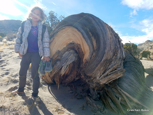
Still barefoot, Desert Girl poses next to an amazing juniper root.
When we got down to the wash, we spent more time looking for fossils. Within the Ordovician Upper Pogonip Group, the Kanosh Shale was very easy to find. The dark olive color was easy to spot from a distance. Hintze and Davis call it "abundantly fossiliferous" in their Geology of Millard County, Utah (2003).
We had climbed above it to reach the summit, passing through the Lehman Formation, Watson Ranch Formation, and Crystal Peak Dolomite to the Eureka Quartzite at the top. Supposedly there are some fossils in some of these layers, but we didn't find them.
Desert Girl had come prepared with a rock hammer and a magnifying glass. She showed quite a bit of patience combing through the layers for fossils.

Here's a map of how we hiked. The more traditional approach is from the southeast side instead of the northwest side we took. I think our approach was steeper but more direct. We probably didn't see as many fossils as the other side, but we did have fun in the sand.

We had worked up quite an appetite on our hike, so we ate lunch as we drove (leftover turkey sandwiches, yum!).
We drove around the south end of the mountains and then north up to Ibex playa. We passed Ibex well and a couple ponds, then got to what I call a good bike loop. There's sort of a racetrack that is lots of fun.

Then we decided to just ride where ever we wanted on the playa. It is such a cool feeling to be able to go any which way we want.
The lighting and clouds was quite dramatic.
We followed Desert Boy around "the island," a big rock outcropping in the middle of the playa. On the way back the wind became a lot more obvious, along with the lenticular clouds.
Our dog Maggie was so happy to run and run.
So much fun!
Here's a closer look at Ibex Playa. We went bike riding at the southern end and then around the Island. Then we headed to the cliffs at the northern end.

It was time to try some rock climbing! It had been awhile since I had lost rock climbed, so I was happy to find a place we could top rope. It was a big boulder to the north of the corral, and we could walk around the backside to the bolts on top.
We took turns climbing. The kids managed in their gym shoes, but my brother and I gave our old climbing shoes a go. We climbed a couple times and then it was getting late and colder, so it was time to head home.
We were so glad to be outside, enjoying the fresh air. We saw two other vehicles on our loop that day, but the occupants stayed inside. So we just about had it all to ourselves. Hopefully we'll be back for more fun!


1 comment:
Wow!..If I'm ever able to get down that way again, I want to see that area...
I wish your map showed the relation to Baker so I would be able to picture the location better..
I'll worry about that later in life...
Upriverdavid
Post a Comment