Showing posts with label bristlecones. Show all posts

Sunday, June 1, 2025

Snake Creek Overlook Trail, Great Basin National Park

With family in town and ready to stretch their legs, we headed up Snake Creek. At first we thought we would do the Serviceberry Loop trail, but decided we didn't have enough time. So we started on the Snake Creek Overlook trail (highlighted in orange on the map), a trail I wasn't familiar with.

It starts at the end of the Snake Creek road, on the same trailhead as Dead Lake. It's a lollipop hike, with a straightaway, then a loop, and then back to the straightaway to return.

The trail veers off from the Dead Lake trail and crosses the creek to go to a couple walk-in campsites, which were occupied.

There are even picnic tables and fire grates at the walk-in sites.

We finally remembered to do a "before" shot.

We followed an old road up to a sign that showed we were at the loop section. We didn't know if there was a better direction to go, so we arbitrarily went left.

Lots of Oregon grape aka creeping mahonia (Mahonia repens) was blooming.

At the top of the loop is this huge dead ponderosa pine. Some live ponderosa pines are nearby. 

We thought the overlook would be at the top, but didn't see anything, so we started hiking down.

Then we found a bench with a glimpse of Pyramid Peak.

From here, the trail was back to an old road, so was more gradual.

I enjoyed seeing the manzanita (Arctostaphylos patula) blooms.

Desert Boy is going to be doing an internship at Great Basin National Park this summer, so I thought it might be good to see what he knows. Could he match the foliage with the pinecone?

Do you know what each of these pinecones/foliage are? Answers under the photo.
From left to right: ponderosa pine (Pinus ponderosa), Douglas fir (Pseudotsuga menziesii), white fir (Abies concolor).

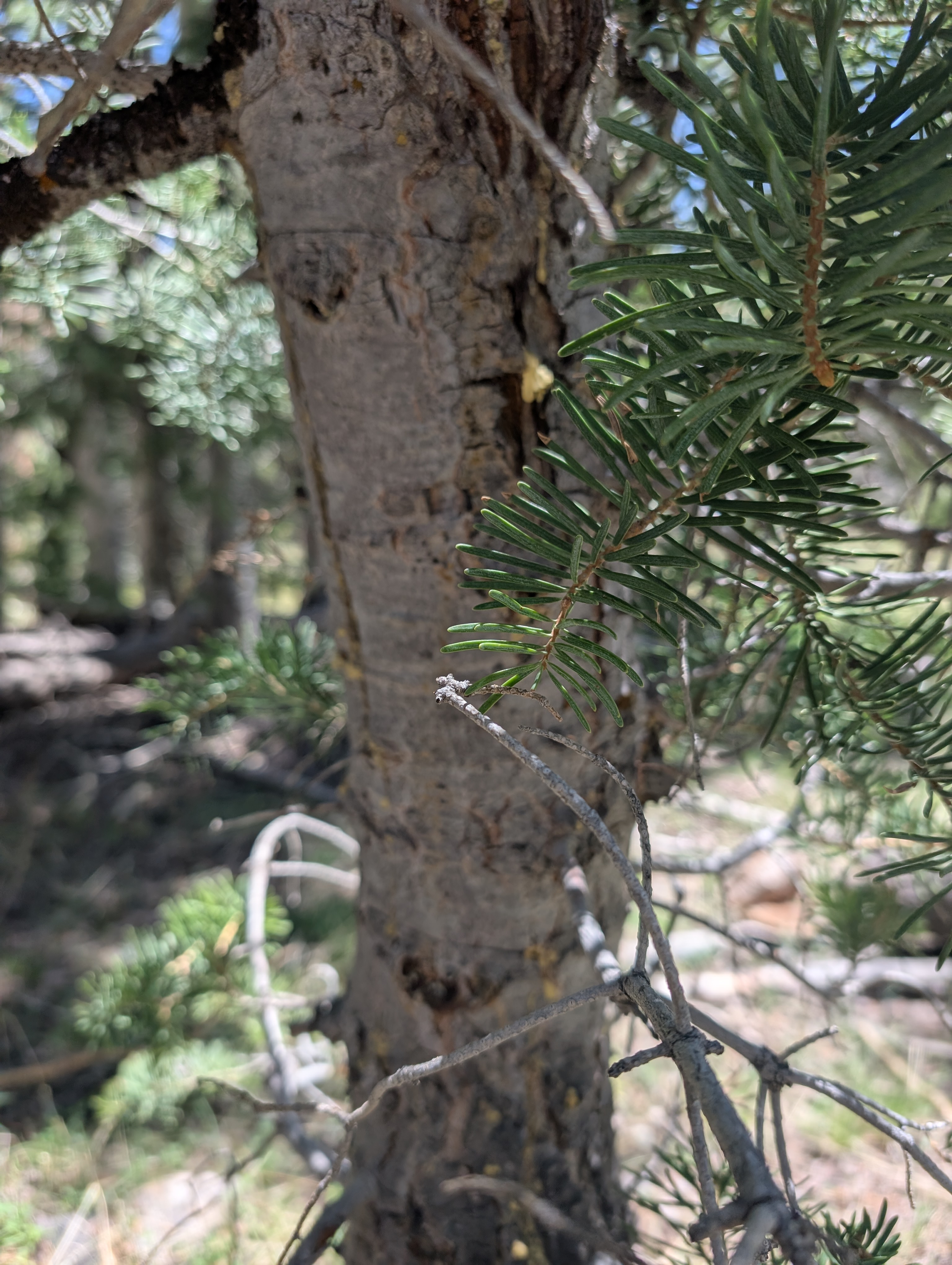
Here's the white fir closeup, with grayish-green needles and rather smooth bark on the trees.

And here's Douglas fir, with a darker green needles and flakier bark.

While Desert Boy was puzzling it out, I noticed a different looking tree nearby. It's a bristlecone pine (Pinus longevae)!

Then it was back to the parking lot, which has some nice views of the limestone Eagle Peak.

The short hike was just what we needed to stretch our legs and see a couple interesting sites. This would not be a hike I would recommend as a destination hike, but it's fine if you have some extra time and are looking for something off the beaten path. Or if you are trying to hike all the trails in the Park this year!

Sunday, September 8, 2024

Day 3 of 3-Day Backpacking Trip in Southern Great Basin National Park

Here's Day 3 of a romping good backpacking trip in southern Great Basin National Park.
Day 1 I started in Snake Creek and hiked down North Fork Big Wash, up South Fork Big Wash, and slept in North Fork Lexington.
Day 2 I continued up and over Granite Peak to Mustang Spring and up and over to Lincoln Peak.

That meant Day 3 I was starting near Mt. Washington and I was headed back to the trailhead to complete the loop. I set up my alarm for 4:30 am so I could climb Mt. Washington and descend the other side to the Magic Grove. I really wanted to be at the Quarter Tree for sunrise. 

I got there a bit before sunrise, so why not do the Tree Pose near one of my favorite trees?

And then the colors started popping as the sun came up. It was so magical!

So much beauty. I couldn't really take it all in. Just wow!

And the views didn't stop. I was just in so much awe.

Finally I decided it was time to continue. Here's my hiking shadow.

The tree was pointing the way!

The good views didn't stop. The dramatic cliffs of North Fork Big Wash and Lincoln cirque highlighted the wildness of this place.

I kept on trekking, getting a bit lost on the Snake Divide Trail. It's not really a trail. It's a route. Or maybe just a suggestion in places. So if you go up there, be sure to have a GPS or GPS app on your phone. Some sections are starting to get more heavily eroded, so hopefully a trail crew can get up there and put in some water bars. And mark the places where it's easiest to get off trail!

I saw one other person on the trail, during the three days, an off-duty maintenance employee about a mile from the trailhead. It was a lovely, quiet get-away. When I got back to the Shoshone trail, I noticed one of the waterbars had NCC on it -- Nevada Conservation Corps. They're a crew that the park hires to help with trails. 

Their waterbars were doing a wonderful job of getting the water off the trail!

And then I was back to the accessible fishing area on Snake Creek. Back to water! And back to my regular life.

This turned out to be an excellent adventure. It definitely had a lot of off-trail and bushwhacking parts to it. Having hiked many of these sections before gave me confidence to link them all together. Water was the biggest thing in my head, as there are so few water sources in the southern part of the Park, but they all worked out fine. I didn't mind all the ups and downs of the terrain, probably because I kept my pack fairly light. I purposefully didn't keep careful statistics or track what I did. But it was somewhere in the range off 30 miles and 11,000 feet up and 11,000 feet down. I used most of what I brought with me, but definitely overpacked the food. I could have done without the sun umbrella, although I really did enjoy it on day 1. I could have left the stove behind, and might for some trips now that I know cold soaking is a decent alternative. 
If you're thinking about going out and doing something wild, go for it! It does the soul good!

Thursday, September 5, 2024

Day 2 of 3-Day Backpacking Trip in Southern Great Basin National Park

Day 2 of my three-day southern backpacking trip in Great Basin National Park. (Here's Day 1.)

I started the day in the lower right hand corner of the map, on the yellow line near Lexington Arch. 

My big goal was to get up to Granite Peak. It's a somewhat isolated peak with no trail to it. There's not actually any granite near it, just limestone. And I hadn't climbed it ever! I was thinking I would spend the night at Mustang Spring, or possibly a but further north.

I woke up a little later than I wanted to, at 6:05 am. Geez, what a slacker (lol). 

It took me 20 minutes to pack up and I headed up the old road behind the cabin. It twisted and turned and had clearly been washed out for awhile, with some older foot travel visible. I knew this was a back way to Lexington Arch, although I had never taken it. I enjoyed finding a little ponderosa pine seedling. Ponderosa pines thrive with low-intensity fire, as it allows their pinecones to open and the seeds to fall to the ground and germinate.

As I kept hiking I found a lot of elk sign, including a spot where one had recently bedded down, then got up and peed. I looked around, and not far from me was a big bull elk! As soon as he saw me, he took off running. I was just outside the national park, and apparently the elk knew it.

I enjoyed seeing some shadows on the burned landscape as the sun rose. Here are some yarrow flowers.

As I looked to the east, I saw a familiar form take shape--Lexington Arch! I did a little happy dance! I wasn't expecting to see it, so what a lovely surprise!

I kept hiking up. And up. And dodging tree branches. And then ahead of me I could see three peaks. Granite Peak is the one on the left, with the long, flat summit. Oof, it looked far away.

I just kept plugging along. I enjoyed these orange lichen-covered rocks. Off to the north I could see Pyramid Peak and beyond that, Wheeler Peak and Doso Doyabi.

I welcomed the cloud cover, which made it a little cooler. 

The bristlecone pines take such wonderful forms! I took a little break near this one so I could enjoy it longer. My path? The rocky slope behind it. As you can see, there's absolutely no trail.

I got some views into the upper part of South Fork Big Wash, which has some awesome cliffs. Speaking of cliffs, at one point when I was down climbing along the ridge, one of my empty water bottles fell out of a pocket and bounced down the cliff and into the trees below. It kept rolling, and I knew I wouldn't be able to retrieve it. I felt bad about littering. On the bright side, I felt good that it wasn't my body going down the cliff. Later I found a helium balloon and packed that out, so I felt a little better about removing trash.

I kept hiking. And hiking. And, then, finally, I was at the summit of Granite Peak!

Here's the view looking south, towards Decathon and Highland Ridge Wilderness. Not a building in sight. This is so remote.

A summit register was in a jar in the rock pile. I was the only person for 2024 to sign in so far. Whoop, whoop! I read through the entries and found that I'm not the first one to do this backpacking route, someone did it a few years ago. Or at least they planned to, I'm not sure if they made it or not! There was also someone with extensive plans from the Lexington trailhead.

And here's my pack, a Gossamer Mariposa 60. I loved it. I took out the back pad to sit (and for extra padding at night). So many pockets kept everything easy to access. And best of all, it was very comfortable.

After a celebratory snack at the summit, it was time to head towards Mustang Spring. This was more hours of tough hiking, basically following the ridge.

Using my GPS app, I was able to find Mustang Spring. I only had about half a liter of water left at this point, so I needed this spring. The animal trails helped lead me there. There wasn't much water, but it was enough. I dug a little hole and then used a cup (from the stove--so I can say I used a part of the stove!) to fill up my filter. Earlier in the day I had been hoping to get to Mustang Spring by noon, but I got here at 2:30. I took a nice hour-long break, including eating and filling all my water bottles, plus watching the birds--red crossbills, dark-eyed juncos, and mountain chickadees, hang out at the spring.

Next it was time to head towards the ridge to the north. Along the way I found this rock, which I think is a fossil.

The views were just lovely, with yellow snowberry and currant bushes. 

I found that I was on the "new" Highland Ridge Route, which goes from Mustang Spring to the north, following the drainage, and then meets up with the ridge just south of Lincoln Peak. Years ago I hiked the "old" Highland Ridge Route, which stays up high on the ridge and only goes down into Decathon near the southern park boundary. There's not a marked trail for either one, so it doesn't really matter which one you take, as long as you know where you are. (And if you need water, Mustang Spring is the only spring between Decathon trailhead and Lincoln Peak.)

The late afternoon light was gorgeous. I got so much energy just being in such a beautiful place.

But then it got even better. The little sprinkles turned into a rainbow over South Fork Big Wash! Another little happy dance!

And then it was time to eat again. I was absolutely starving, but fortunately I had put water into my dinner at Mustang Spring (and into an additional ziploc bag, which was good, because the Mountain House package didn't seal too well). It had cold-soaked long enough and was perfect. I thought I might just eat part of it, but I ate the whole package while I watched the clouds float by.

I started hiking and another rainbow came out. How lucky! 

Later I saw a golden-mantled ground squirrel. What a cutie.

Then I noticed I could see my shadow hiking. Can you spot me below?

I still had to get up Lincoln Peak, but Highland Ridge at golden hour is insanely beautiful, so I didn't mind the continued hiking.

I turned my phone off airplane mode and called my husband as I approached Lincoln Peak. At the peak I saw someone had signed into the register that same day! Cool. It soon got dark, but I felt like continuing. I had hiked this section in the dark with a headlamp several times coming back from bighorn sheep searches and caving trips. I definitely needed my GPS app to find my way, as there are no markers or trail, and once you get down in the trees it gets very confusing.

Fortunately I got to the road and continued for a ways until I found a flat spot with little rocks to call home for the night. What a great day 2!
Just one day left!

Stay tuned...
Related Posts Plugin for WordPress, Blogger...

blogger templates