
After a half-day touring the park (blog post on that coming soon), we met at IMG headquarters in Ashford, Washington for our orientation and check in. We met the other six clients on the trip and the lead guide, Dustin. He went over the National Park Service mission, Leave No Trace principles, the schedule, weather forecast (which had very high winds that would possibly decrease later in the week), and then we went through a very thorough gear check. Every item we wanted to take up the mountain was examined. If it wasn't on the list, it went into our "luxury item" pile, and at the end we could only pick two or three from that.
My husband had brought his Grandma's ice axe that had been to the top of the mountain. She and my husband's grandfather, a climbing guide for ten years, got married on top of Mount Rainier in 1937 or 1938. The ice axe didn't pass the specifications for modern day safety gear, but the guide would let my husband take it as a luxury item. Ultimately he passed, which was probably good.

The next morning we met at 8 am at headquarters and drove an hour to get to Paradise, the jumping off point for our climb. It's also one of the most popular places in the park, but because it was so clouded in, we had the paved trails almost to ourselves. We loaded up our packs (which weighed 30-35 pounds), and started heading uphill.

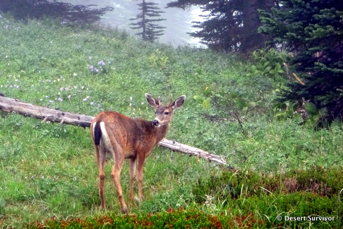
On the way we saw black-tailed deer (Odocileus hemionus columbianus), a subspecies of mule deer that has an all black tail. (Isn't it nice when the description is part of the name?)
One of the things that surprised me most at Paradise is that the profusion of flowers was still in bloom. I had thought that by early September many of the flowers would be fading at 5,400 ft.

The clouds made me look even more closely at the flowers, and the hike went fast, even though we were going at a very slow pace.

The moisture was evident everywhere, including these lupine leaves, which I photographed at our first break, a bit over an hour in. We had 4.5 miles to hike, gaining 4600 ft in elevation, and the guides had told us that we would hike an hour and then break for ten to fifteen minutes and then continue. This would get us ready for the higher mountain and how we would hike and break there.

Not long after the first break we encountered snow. I was quite excited! This trip was getting more real! As we hiked, the four guides moved around, talking to us and getting to know us better and sometimes offering advice on how to hike more efficiently.

We eventually hiked higher than the clouds and got our first glimpses of Mount Rainier. The mountain seemed so magical.

At our second break, my husband and I posed for a quick photo before putting on our mountaineering boots and gaiters.

We were now hiking on the Muir Snowfield. We walked in single file at a very measured pace, again practicing for the upper mountain.

As we approached the third break, I noticed that behind us we could see Mount Adams peaking out above the cloud layer. We put on crampons at the third break, as the conditions were rather slippery.

It was much easier to hike in the crampons than I was anticipating. It was also quite warm.

The warm weather this summer coupled with a lack of precipitation (and possibly other conditions) means that crevasses have opened up in the Muir Snowfield, exposing deep ice below. So this snowfield could more accurately be called a glacier. Our guides took some close looks at some of the crevasses.

Finally we were getting close to Camp Muir, our home for the first night at 10,188 ft. We saw various buildings, including a brown rectangular hut that was to be our dwelling.

They called the place the Gombu in honor of a sherpa that had done a lot of climbing on Mt. Rainier and other places in the world. Inside we found triple layer ledges. The highest was for storage, and the other two were for sleeping. The eight clients would sleep here for the night in one half, while another guide company used the other half for their clients.

While we were getting settled in, I had a chance to run over and say hi to Eddy. I had spotted him down in the parking lot as we were getting ready. We met at cave rescue training in May, and I had heard about his work exploring some of the glacial caves on Mount Hood (the link is to an amazing story). He told me that he and his crew were heading up to the top of Mount Rainier to do a reconnaissance trip to get ready to do a major survey next August. They were planning to spend some nights at the top. How cool! We hoped we would see each other at the summit in a couple days.

We had a little free time, so my husband and I wandered over to the public shelter, built in 1921 and dedicated to John Muir. It was set up very similar to the Gombu, with platforms for sleeping, along with some bins for gear storage.
Two climbers in there told us they were planning a summit attempt that night. When they were younger, they used to climb the mountain in a day and a half, leaving Paradise in the afternoon, getting up to Camp Muir, sleeping a few hours, then heading to the top and all the way back down the next day. Now they take four days, one day to the camp, one day to rest, one day to summit, and one day back to Paradise. They also shared their favorite mountain meal: top ramen. They used to do Mountain House, but ramen was a lot cheaper and provided a lot more sodium (which we later learned we should have paid more attention to!).
A couple was also spending the night, but they had just hiked up from Paradise and would return the next day. Apparently in July and August, the shelter can have 20 climbers squeezed in and it's hard to get much sleep, but in September during the week it was much quieter.

Just beyond the buildings was a sign that recommended climbers to rope up before crossing the Cowlitz Glacier. Crevasses were evident, as well as paths that had changed to avoid crevasses that had opened up during the summer.

Soon we headed over to the WeatherPort for dinner. The guides made delicious burritos for us. We listened to some stories, chatted, then headed back to the Gombu. Our goal was to rest from 7 pm to 7 am so that we would acclimatize and save up energy.

I really wanted to see sunset, and a pee break allowed me to catch some color on the clouds. The clouds moved continuously and were fabulous to watch.

My husband managed to catch sunrise on an early morning pee break, with the early rays on the Cowlitz Glacier.

Following a delicious breakfast of bacon, hash browns, and pancakes, it was time for class. We learned cramponing techniques, use of an ice axe, how to self-arrest in various positions, and how to rope up.

Then it was time to rope up and go. We were all so excited to be moving up to the next part of the mountain. The crevasses were intimidating. We hiked up over Cathedral Gap and then onto the Ingraham Glacier.

The crevasses gaped bigger and deeper. In one I could see the passage bell out and icicles decorate the room. It was gorgeous, but I couldn't stop for a photo because boulders littered the trail, and we had to move quickly through this rock fall area. Our guide did let me stop for a photo as we got closer to our camp. Can you see the tents in the photo below? They aren't all that far from the huge crevasse!

This camp was at Ingraham Flat at 11,100 ft. It took about an hour and a half from Camp Muir moving at a very slow pace to get to the flat. IMG and Alpine Ascents already had tents set up (they alternate nights using them). This was one of the reasons we had chosen IMG, because we would get to spend two nights on the mountain, and I wanted to maximize the time on the mountain.

At 2:30 pm we had a summit talk. Dustin told us how to pack our packs, how much food to bring, and what the schedule was. We were all feeling great. It was relatively warm and calm, although we had by this time learned to always put on our puffy jackets when we stopped.
 |
| Our group (minus the guides) |

We had a simple dinner, then retired to our tents at 4 pm. The guides told us to sleep as much as we could, and that we would probably get woken up between 1 and 2 am for an alpine start. The idea was to get off the most dangerous part of the mountain before afternoon sun loosened up snow bridges and rocks and other hazards. It was not at all easy to sleep. Part of the problem is that we had to pee so much. We were trying to stay hydrated, so we kept drinking lots of water, but we didn't get enough salt, so it just went right through us. It was a chore to put on the boot liners, open the tent, put on the boots, than open the fly, and go to the pee hole and then return. We eked out a little sleep, but the anticipation of the climb made it difficult, plus the big wind gusts that rattled the tent and then made me worry how much windier it was high up on the mountain.

The next morning we got woken up very early. We packed up our gear and went to the food tent for some hot water for soup or oatmeal and coffee. Then we put on our harnesses and crampons and roped up. The guides had told us to wear long underwear under our softshell pants. I wasn't sure about that because it seemed relatively warm at camp. But I had learned always listen to your guide, as they had tons more experience than we did.
After we left camp, we went higher up on the Ingraham Glacier and walked over some ladders that crossed crevasses. We couldn't take any photos for safety reasons (although a couple guys had GoPros and I look forward to seeing their photos). One crevasse had opened up in just the three days since the lead guide had last been there, so we had to take a really big step to get across it. It was exciting. And scary. The crevasse was probably 80 to 100 feet deep and a fall there would not have been good.

The next section we zig-zagged our way up the Emmons Glacier. We followed a trail about a foot wide. We had to walk at the exact speed of our guide, or otherwise our rope would be too short or too long, and neither of those things were good things. I tried not to look down the slope much, as the slope went down steeply for a very long way. It was getting windier and colder, and our guide told us to make sure that we were kicking in hard with our crampons. It was quite icy, so we didn't sink in at all, we stayed right at the top of the icy trail.
For one crevasse, we switched our ice axes from our uphill side to the downhill hand so that we could hold onto a handline and cross a narrow trail with a gaping crevasse just under us. It was something to get across really quickly. Then we turned and started going up a steeper hill. The wind was even stronger on this shoulder of the mountain, and the lead guide came to a sudden halt and asked for the other guides to come up and meet him. So the guides were all huddled together, with the rest of us strung out below, our backs to the strong wind, trying to make sure we had good footing. We looked at each other, knowing that this was something out of the ordinary and did not bode well. Sure enough, the guides came back and told us that we were turning back. We had made it up to 12,800 feet, but it was too icy and windy for us to continue.
We were all extremely disappointed, but there was no arguing. We had paid the guides for their expertise, and they clearly knew the conditions better than us. When we got back to the top of Disappointment Cleaver, the lead guide told us more about his decision. He said this was the iciest he had seen the mountain so far (he had made ten summits so far this season), and coupled with the strong winds, he wasn't sure if the guides would be able to arrest a fall if anyone stumbled. Perhaps Eric Simonson said it better in Mike Gauthier's Mount Rainier: A Climbing Guide: our group did not have the advanced cramponing skills necessary to continue. It made sense, but it was still so hard to stomach not being able to continue on to our goal.
As we hiked down Disappointment Cleaver, the sun came out.

Now we could see the magnificent scenery even better. I was able to take a few photos as we waited for another group to pass us on their way up. They were on a six-day mountaineering skills seminar. We wanted so badly to turn around and go back up with them. With their extra skills training and later start (they only had to go back to Camp Muir that day instead of all the way back down to Paradise), they were better equipped. And checking their blog, it looks like they made it. Good for them. Because not making it to the summit really sucks!

Despite not making it to the top, the scenery was stunning, and we really got to see a lot more of Mount Rainier than most people. I was absolutely enthralled with the glaciers and their magnificent crevasses. It was also great learning some new skills.

We had a good view of our camp at Ingraham Flats on the way back down. The tents give a sense of scale of how big those crevasses are.

After packing up the rest of our gear at Ingraham Flats and a brief stop at Camp Muir, we headed back down the Muir Snowfield. That was probably the hardest part of the whole thing, as we went nearly straight down and my feet weren't too happy in the mountaineering boots. We kept on the crampons because it was so icy and the wind was really strong on our backs.

We carefully stepped over the crevasses, as we didn't want to have an accident here--the guides had stored their climbing equipment back up at Camp Muir, so it would take awhile to get someone out of a crevasse.

The hike just up to Camp Muir is really awesome, and we talked about taking the kids up there in a few years. It's not technical (especially in July or August), but it's a great experience.

As we headed back to Paradise, the sun was out (with the cold wind), and we could see the Tatoosh Range, Mount St. Helens and it's blowing smoke, and various other volcanoes. The trails were crowded with people out enjoying the views.

It was a good point. Despite our disappointment of not making it to the tippy top, we were alive, and that was the most important thing. We got to see some marvelous scenery and enjoyed being together. It's certainly not an anniversary that we'll forget! My husband says he has no desire to go back to the high mountain, but if the right opportunity presents itself, I would go back.
On the way home, we got to see the summit crater from the airplane window. It looks great!


5 comments:
It sounds like a great experience - from the idea to the training to the actual trip. Thanks for sharing it.
Thanks for sharing Gretchen! What a beautiful adventure!
I am in awe of you!!! Congrats!
What an amazing journey! Since I never endeavor to climb/scale a mountain, I enjoyed your experience unfolding from my couch. I can't believe the crevasses you had to jump and maneuver over. Incredible!! What a fabulous 10th anniversary gift to and for each other!
I stumbled upon your blog while looking for fun adventures around Utah, and I have been pouring through the blog for hours! I love your photos and you've been to some places I've never heard about. You are a great writer and I will be checking back frequently! Thank you.
Post a Comment