Last week I had the opportunity to climb several mountains as part of the
GLORIA project, a world-wide project that is looking at climate change by studying how plant species are changing on mountain tops over the long term. The basic idea is that as the climate warms, plants will have to move upward in elevation to survive. Eventually they will reach the top of the mountain, have no where else to go, and will disappear. Yikes!
One of the four peaks we studied was Wheeler Peak, at 13, 063 feet the second highest peak in the state of Nevada. The hike is 4.1 miles long starting from the Wheeler Peak summit trailhead at about 10,000 feet. To get to the trailhead, you simply enter Great Basin National Park via Nevada Highway 488, then take the Wheeler Peak Scenic Drive about 12 miles to the sign.
After a briefing about possible dangers (lightning, altitude sickness, hypothermia, tripping and falling, dehydration, etc.), we set off through the aspen groves on a rather flat section of trail.
After a mile, we reached the second trail junction, with Stella Lake nearby and the summit of Wheeler Peak only 3.1 miles away. Only. Ha.
The trail gets progressively steeper, and the peak still looks far away! Wheeler Peak is the high peak on the right, while Jeff Davis is on the left and stands about 400 feet lower. Wheeler Peak is named for Lieutenant George Wheeler, who summited and surveyed the peak in 1869 as part of an Army mapping expedition. For more on the history and climbing the peak, see the highly recommended
Great Basin National Park: A Guide to the Park and Surrounding Area. (Disclosure: I wrote it, so of course I highly recommend it!)
Before long we were above treeline and following switchbacks up the talus. Although we were gaining 3,000 feet, before the Scenic Drive existed, people would either ride horses up part way or start hiking about where the Upper Lehman Campground is, just short of 8,000 feet. And Wheeler started in Spring Valley at 6,000 feet, for a 7,000 foot elevation gain. (albeit with a horse for part of the way!).
More than half way up is a giant shoulder that is sort of flat. Some big wind breaks have been created. The wind sure can blow up here, and it's usually cold! Be sure to bring some extra layers.
During our rest break, I found one lonely little snow cinquefoil flower (
Potentilla nivea). The rest of the flowers are wrinkled up and barely noticeable.
As we continued up, I commented on the flat areas with no vegetation. usually vegetation seems to like the flatter areas. I learned that these may be periglacial features. The movement of the ground due to freezing and thawing keeps it unsteady (or something like that, I'm not entirely clear about periglacial features).
A lot of planes fly over Wheeler Peak, and that particular day the contrails were staying put, giving an idea of just how many fly over in a short amount of time. Across the valley I saw my first ever contrail shadow.

A skunky-smell started permeating the air, and I looked around closely to find skunkweed or sky pilot (
Polemonium viscosum). Beautiful purple flowers are suspended on some stinky upreaching leaves.

Then came a surprising sight: Parry's primrose (
Primula parry). This species usually grows next to streams (the inlet to nearby Teresa Lake is a beautiful spot). Somehow, these flowers have been able to adapt to live in the alpine environment.
Although the oxygen became more limited the higher we went, the views kept improving. Soon we reached the summit and could look over the mountain top.
From the top we had the glorious view of the south Snake Range, beginning with the North Fork of Baker Creek, and continuing down to Pyramid Peak (it really does look like a pyramid!), Mt. Washington (the light gray peak), and Granite Mountain in the far distance.
Up on the summit are several round shelters. These just aren't for sheltering day hikers, they were used as part of a heliograph station to map the 39th parallel. They have a really interesting history (see Chapter 5 in the Great Basin book).
We began our vegetation resurveys on the west shoulder of Wheeler Peak, which has less disturbance. We used a variety of different survey types to document what vegetation is present. We also retrieved data loggers to find out what the temperature has been like for the past five years. Over the next months, that data will be studied to make some preliminary conclusions. Five years really isn't much time to see huge changes in plant communities, although we did see a couple of ferns that weren't spotted last time.
This rockslide yellow fleabane (
Erigeron leiomerus) was outside of our survey area, but was one of the few plants still flowering. Due to our very dry conditions this year, most flowers were past their prime.
During a break, I walked to the far east edge of Wheeler Peak's summit to get a view of the rock glacier in the cirque below. Check out
this post for a close-up view of the rock glacier.
I really wanted to see the glacier at the headwall, so I moved closer, and was stunned when I realized that the ice ascended nearly all the way up the steep face. It looks so much different than from down n the glacier. The slope is covered in dust, gravel, and rock, but it's smooth surface left no doubt that it's ice. I felt a moment of realization that this really could be a glacier. (I will admit that I've been a doubter, even though
Osborn and Bevis have declared it a glacier in scientific literature.)
One of the definitions of a glacier is that it must be moving, and crevasses (cracks in the ice) show that the ice is moving. I zoomed in for a closer look at the crevasses. It would be kind of cool to get really close with an ice axe, rope, and crampons, and check them out more. The only problem is that there is
so much rock fall off the Prospect Mountain Quartzite--hence the very dirty glacial ice.
Then it was time to get back to work looking at plants. The Ross' avens (
Geum rossii) with its yellow flowers is one of the most common plants on all the peaks we looked at.
I only found a few cushion phlox (
Phlox pulvinata)
in bloom during the trip; most of the flowers had already disappeared.

We finished our work in the mid afternoon. Before heading down, I took a photo looking east, over Garrison in Snake Valley and the Burbank Hills to the Confusion/Wah Wah Range and beyond. If you know the area, can you spot
Crystal Peak?
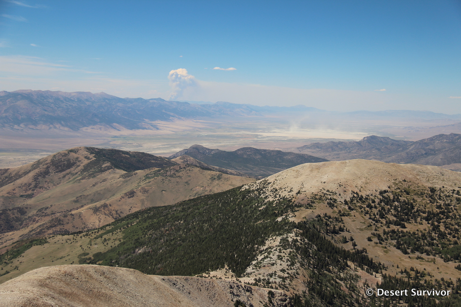
The afternoon heat allowed for a wildfire to the northeast of Spring Valley to produce an impressive smoke column. We also saw a lot of dust kicked up on Yelland Dry Lake bed. During the spring, the
playa will be covered with water, but for most of the year it is dry and dusty. Many people fear that more of Spring Valley will become like Yelland Dry Lake bed due to
a massive groundwater pumping project by Southern Nevada Water Authority that is expected to significantly drop the groundwater level in the valley and change the plant composition.
It took me about three hours to hike up Wheeler Peak (with people in our group both ahead and behind), and about two hours to hike down. It was a beautiful day to go up to the highest point in this part of the world.
Hope you enjoyed seeing some of the views! What's your favorite peak to hike?


 Then came a surprising sight: Parry's primrose (Primula parry). This species usually grows next to streams (the inlet to nearby Teresa Lake is a beautiful spot). Somehow, these flowers have been able to adapt to live in the alpine environment.


3 comments:
Great views of the glacier and rock glacier -- in this post and in the July post, which I somehow missed until today (work, perchance?).
Great photos! One quibble - if you asked the folks who built those round rock shelters, they'd have said they were using "heliotropes", not "heliographs".
Surveyors were using heliotropes long before heliographs were invented, and long after heliographs fell into disuse, though GPS surveying finally pretty much put an end to the practice in the late 1980s.
A great book on this survey is "Geodesy: the transcontinental triangulation and the American arc of the parallel", 1900, US Coast and Geodetic Survey. You can read it on Google Books: books.google.com/books?id=--MNAQAAMAAJ
If you search inside that book for heliotrope, you'll find 8 references - for heliograph, none. Plate 41 (preceding page 553) shows a heliotrope set up outside one of the rock rings. Plate 37 is a closeup of three heliotropes. For more about heliotropes, see: http://en.wikipedia.org/wiki/Heliotrope_%28instrument%29
Thanks, Flashes of Light. Good to know more of the story!
Post a Comment