Every time I drive to Ely, I look at the Schell Creek Range and think to myself, "Wouldn't it be great to walk along that ridgeline?"
After all, the Schell Creek Range is the longest range in Nevada (arguably, apparently), at 132 miles according to this article. The High Schells Wilderness was designated in 2006 to protect some of the highest parts. How high? North Schell Peak is 11,883 ft, Taft Peak is 11,734 ft, and South Schell Peak is 11,765 ft.
Several years ago, my husband and I took the kids on a trip up North Schell Peak. It was wonderful, and we wanted to go farther along the ridge.
After dreaming, I decided 2022 would be the year. We set a date for July. My husband was too busy, and the weather was way too hot and sunny. We postponed. We played with a date in September. It didn't work out either. Finally, we decided to go the first weekend of October. I thought it would be too late for good colors, but we are having a late fall this year, and the colors were at their peak. The temperatures were fantastic. And it was quite a trek. Here's our story.
I looked on the Internet to get some beta for the hike. I couldn't find any. How long was the hike? Was there any water available?
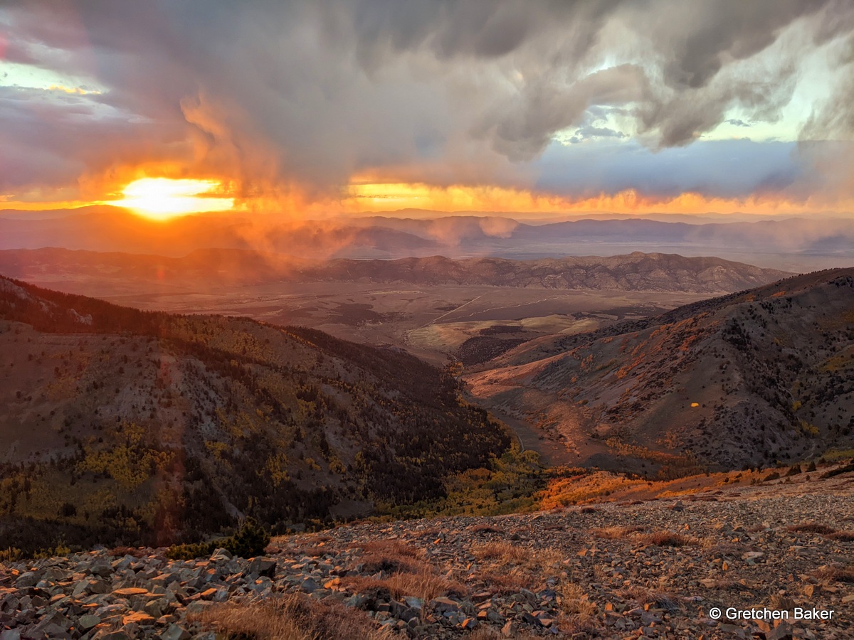
I had to turn to Google Earth and figure it all out on my own. It looked like Timber to Cleve Creek was about 15 miles. No water available. So we packed 5 liters each and hoped that would be good. We staged a car at Cleve Creek (AWD, medium clearance, highway tires and slow going but not too hard) and drove around to Timber Creek Trailhead. This ended up taking much longer than I had planned; not 2 hours, but 4 hours! So we got started on the trail about 1:30 pm. The cloudy skies heightened the fall colors as we followed the trail from the trailhead.
We head a little thunder and questioned our sanity of going up to the ridgeline. The clouds were scattered, so we kept going.
We had to take some breaks, and at one I burst out laughing when I found out what my husband had packed for snacks. He had made an early morning run to the Border Inn and stocked up!
We continued up to our first peak, North Schell Peak.
The quartzite rock is beautiful.
At the top we could look down at the beautiful quilt of colorful trees carpeting Timber Creek. It was amazing. But we didn't dare stop long. It had taken us three hours to get to the peak, and this was just the first of four sections to cover. My notes had Trailhead to North Schell Peak being 2.5 miles and 2700 feet elevation gain. In reality, it was a bit over 3 miles to get up there.
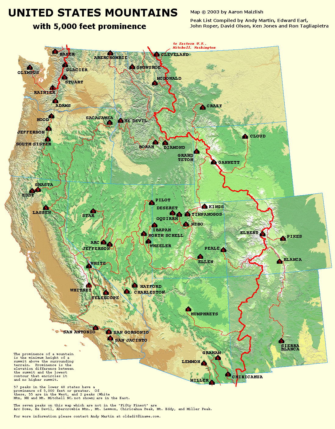
Fewer than a dozen people had signed the peak register for 2022. Most were from out of state. Many had climbed North Schell because it's on a list of the 57 US Mountains with 5,000+ feet of prominence (in the lower 48).
Source:
western_usa_prominence_map.gif (1098×1404) (cohp.org)North Schell Peak is #40 on the list of 57. (By contrast, nearby Wheeler Peak is #12). More on prominence: AMERICA'S 57 - THE ULTRAS (peaklist.org)
Although it was October, I kept seeing blooming flowers. I was so surprised! Here is some gorgeous phlox.
As the sun kept approaching the western horizon, the light got so good. I was trying to snap photos and hike simultaneously, not an easy feat! It was just amazing. But the section from North Schell to Taft Peak, our second section, was 5 miles long, with over 2,000 feet elev gain and loss. We obviously wouldn't make it all the way, but we wanted to put a good dent in it.
We kept hiking and hiking, enjoying a marvelous light show. Occasionally we had to stop for snacks or to put on more layers. It even sleeted on us a little!
Eventually it got so dark and we just had one headlamp between us, so we had to stop. We found a spot that was a little less rocky and set up the tent and ate and went to bed early. It was chilly!
I woke up the next morning and noticed a little pink tint to the light. The sun would be coming up soon, so I jumped up and exited the tent. It was getting pretty fast. I woke up my husband, as it was about 6:30 and we needed to get going to cover many miles.
We ate, shouldered our packs, and started on our way. My husband didn't look super enthused at first.
I found more blooming flowers, which perked up my step.
Some of the ridge was wide and flat. The rock hopping varied from easy to a little annoying, but never that difficult. We were very curious about this depression along the ridge. Maybe there had been some subsidence? Is it a fault or some tectonic shifting?
We had some big ups and downs, and one ridge looked intimidating, but when we got to it, it wasn't too bad.
Finally we made it to Taft Peak! With great hair, lol.
When we opened the peak register, I was amazed that no one had signed in for over 2 years! One person mentioned he had gotten there in less than two hours from Berry Creek.
I really enjoyed looking at the cirques. This mountain range used to have quite a few small glaciers on its upper slopes.
Section 3 was Taft Peak to South Schell Peak, supposedly 1.25 miles with 700 ft elev gain and loss. The ridge up to South Schell Peak looked quite daunting. Was it really just 700 ft?
Craig taking a rare rest break to get the weight off his legs. He was actually like a mountain goat on the slopes, moving quickly along.
And then we were there, at South Schell Peak! We couldn't find a register. And it was starting to thunder. So we skeddadled.
Our fourth section was South Schell Peak to Cleve Creek end of road, about 5 miles and 4900 ft elev loss.
The top of Cleve Creek looked amazing, with another beautiful cirque.
I found a fern nestled in the rocks and geeked out. Ferns in the desert are such a fun juxtoposition.
I had read 4900 ft elevation loss. But when we looked south along the western Cleve Creek ridge, we saw several small peaks we would have to climb. Was this real?!
I could distract myself a little by looking right into the South Fork of Berry Creek. The rainbow of colors down the canyon was so enticing.
As we continued south, we found a lone bristlecone pine. Most of the other trees were limber pines and Engelmann spruce.
I just couldn't stop taking photos of Berry Creek.
The thunder clouds moved off, the sun came out, and we were hot again.
The exquisite alpine paintbrush,
Castilleja nana.
As we moved down the ridge, we kept taking peeks over to Cleve Creek. The colors in the upper section were tremendous.
Then we ran into more obstacles on our ridge, including aspen groves and rock outcroppings. It was slow going.
It was a very long five miles (especially after the previous five miles), but it was quite beautiful. The eastern ridge along Cleve Creek also looked inviting. Maybe another time.
As we descended the very steep last section, we were treated to another menagerie of colors.
Off in the distance, we could see Wheeler Peak in the South Snake Range and Great Basin National Park.
Finally, we made it to our vehicle!
We still had a nearly 5-hour shuttle to go get our truck.
If we did it again (and we might, with the kids), we'd probably do the Timber Creek-South Fork Berry Creek section. That would make for a much easier shuttle and would hit the highlights of the three major peaks. That could also give some time to play around in some of the ridges that extended from the peaks.
Fall was an excellent time for the hike. Although we had to carry all our water (5 L for each person was a good amount), it was cool enough that we weren't drinking a lot. And it didn't get that cold at night, just slightly below freezing.
Final stats:
Day 1: 5.6 miles, 5 hours, 49 minutes hiking, total ascent: 3,957 ft, total descent: 1,470 ft
Day 2: 10.1 miles (and then the Garmin ran out of battery, but it was probably only another .1 or .2 miles more); 8 hours, 36 minutes hiking; total ascent: 2,028 ft; total descent: 4,758 ft
So there you have it, the Schell Creek traverse. It's amazing. Thanks for reading this far!
And one last photo for good measure:
p.s. Number of people we saw on the hike: 0.


3 comments:
absolutely wonderful!
You have taken a lot of beautiful photos over the years, but I think these are the most mind-boggling. That time and place was a for-real wonderland.
I think these photos could win contests, Maybe Nevada tourism would like some of them.
Really, they are extraordinary. And no one else was there ...
I'd say you timed the colors perfectly! That Taft Peak entry was my husband's.
Post a Comment