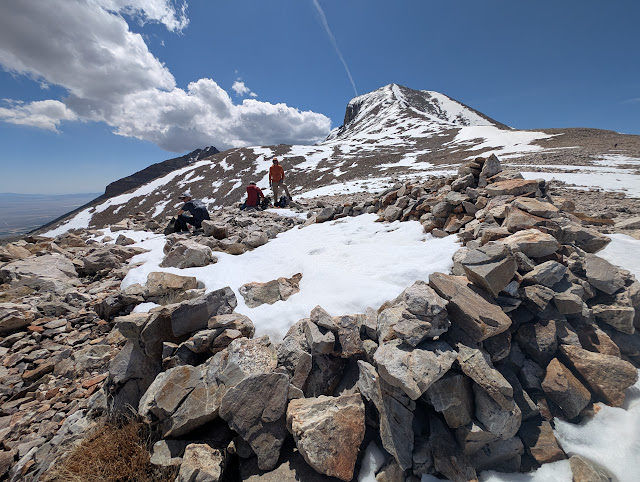
There wasn't much snow on the first part of the four-mile long summit trail, but as we progressed, we found more.
Desert Girl was doing some training by carrying her cousin. The plan was to take him part way up the mountain, then his mom would take him down. He made it about 1/3 of the way up.
As we headed above treeline, the kids surged ahead. The rest of us were wanting more oxygen.
It's both daunting and beautiful coming up that first false summit and then seeing the peak far off in the distance.
And snow was the theme the rest of the way up. Although there were rocky patches, most of the way up was in the snow.
And then we were almost to the top!
The view to the south was gorgeous, looking down into the North Fork of Baker Creek, Baker Peak, Pyramid Peak, Mt. Washington, and the Highland Ridge.
My daughter and nephew walked with me along the summit ridge towards Doso Doyabi, past the wind shelters and old heliotrope stations. These were used to help map the 39th parallel. You can read much more in the bood Geodesy: the transcontinental triangulation and the American arc of the parallel," 1900, US Coast and Geodetic Survey. I did not read it, but I did check that it's on Google Books at: https://books.google.com/books?id=--MNAQAAMAAJ. On page 334, it shows the measurements from Wheeler Peak to Tushar Mountain (near Beaver, UT), Mt. Nebo (near Nephi, UT), Ibapah Peak (near Callao, UT), and White Pine Peak (lost in NV).
p.s. You can learn more about Heliotropes on Wikipedia, including that someone using one could be called a "flasher."Here they are, with Doso Doyabi obviously lower in the background.
The views were spectacular all around. Here's the ridge we had just climbed, with Stella and Teresa Lakes looking like little ponds in the right-center part of the photo.
As the clouds built, we gathered for a group photo.
We signed our names in the register, and then it was time to head down, with microspikes on.
We gave sliding down a try. It worked better on a jacket, as the snow was quite wet.
We had to be careful not to veer to the left, or we'd have a long hike into Spring Valley.
Remember how I said at the beginning that a later start might have a drawback? This was it. We found the snow was now very soft, and the postholing was awful. There were tears.
But we did it! What a day.
This was one of the harder times for me to climb the peak, not only because my body wasn't so acclimated, but also because so much snow made it rather tough. I was so proud of my nephew, doing one of the hardest hikes of his life (so far).


4 comments:
Thanks for the views, I'd never make it anymore..
Specialist in recovery of any kind, they can help you spy on anyone on this earth and get information from anywhere at all, brillianthackers800@gmail.com is group of specialists in delivering jobs like this without stress all they need is the necessary information to get what you need, they are also available on Whatsapp +14106350697 to deliver.
🌟 Client Testimonial: How Morphohack Cyber Service Helped Me Recover My Lost Crypto 🌟
A few months ago, I was scammed and lost access to my crypto wallet, along with a significant amount of cryptocurrency. The emotional toll was crushing, I felt helpless and devastated. After contacting the platform and authorities with no luck, I was stuck.
Then I found Morphohack Cyber Service, a company specializing in crypto recovery. Initially, I was skeptical, but I decided to give them a chance. From the start, their team impressed me with professionalism, transparency, and their deep knowledge of blockchain recovery. They carefully reviewed my case, explained each step of the process, and worked tirelessly to trace the stolen funds.
To my surprise, they succeeded. I recovered my assets and regained control of my wallet. What stood out most was their honesty and commitment, they didn’t promise miracles but delivered results. Throughout the process, they kept me informed and treated me with empathy and respect.
Thanks to Morphohack, I got my crypto back and my peace of mind. If you’ve been a victim of a crypto scam, I highly recommend reaching out to them. They gave me hope when I had none and made my recovery possible.
E-Mail: Morphohack@cyberservices.com....
Are you a victim of any kind of scam?
This expert can help recover all lost funds,,
cyberbeaconservice (A)gmail[.] com
Whats_App, +1..9..0..2..5..0..0..5..4..1..7
Crypto Scam Recovery✅
Bitcoin Scam Recovery✅
Forex Scam Recovery✅
Trading scam Recovery✅
Romance Scam Recovery✅
Investment scam Recovery✅
Tax Fraud Recovery✅
All kind of scam.✅
Post a Comment