Sunday, October 29, 2017

NSS Western Regional at Lava Beds National Monument

Last September I had a chance to visit Lava Beds National Monument, and I loved it so much I wanted to take the kids back. We had the opportunity to do so in early October for the NSS Western Regional, a gathering of cavers. 

Google maps said it's about a 10-hour drive. We went to Fallon the first day, then proceeded via an alternate route the second day. I wanted to see Pyramid Lake, so we did. The lake is surrounded by Shoshone tribal land. We headed up the western side, as Google maps had shown a route that way. I was surprised by the number of anglers along the way. Then we reached the end of the pavement, and a big sign said the road was closed ahead. Uh oh. We were in the van, so I wasn't willing to chance it, so we backtracked. We took a brief stop to touch the lake and admire the cool tufa structures. Then we headed up the east side of the lake. (I guess I was pretty hard-headed about not taking the road more traveled.)

This area is very quiet most of the time. We reached Gerlach about lunch time, and I loved their welcome sign so much that I stopped to take a photo of it. After all, how often are you in the Center of the known Universe?

We ate lunch and found out that about 120 people live in the town year round, but they see about 80,000 visitors around Labor Day week, when the annual Burning Man Festival is held on the nearby Black Rock Desert.

We took more empty roads, crossed into California (without a sign, so it was several miles before we realized it), and passed through some scenic towns. Eventually we arrived at Lava Beds National Monument in time to get our caving pass (to ensure that White-nose Syndrome isn't spread), set up our tent, and register for the regional.

Our first cave was Mushpot Cave, the only lava tube that has lights and a paved trail in it. There are also nice interpretive signs explaining how lava tubes are formed and features in them.


This is the most-visited cave in the park, but we had it all to ourselves. It shows some great lava features. Can you imagine when the lava was flowing through here?


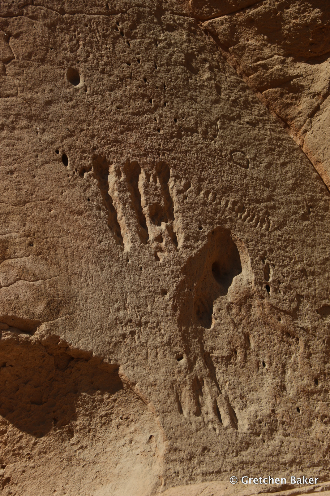
We crossed the road and went into Indian Wells Cave, which used to be a watering hole. We didn't find any water on our visit. But the entrance was gorgeous, and we had fun popping out a different entrance. The kids loved the chance to lead and explore.


We met up with friends and had a lovely evening. The next day we joined a group going to Catacombs Cave. A four-hour trip to do the loop. It involved some route-finding and a lot of crawling, but we made it! Here's one of the kids in the tight connection section.


And a cool root. Most of these lava tubes aren't very far below the surface, so roots aren't too much of a surprise. This one was cool because it had a spider web on it with some condensation.


We ate lunch in the parking lot and then headed to some more caves along the Cave Loop. I wanted to check out some caves that are usually closed due to bats. Here is Ovis Cave.


We ended up coming out a different entrance, wandered across the road, and went into Sunshine Cave.


Then we walked back down the road and checked out Paradise Alley, which runs parallel and slightly higher than Ovis Cave. There's a lookout at one point, with a strong breeze blowing up.


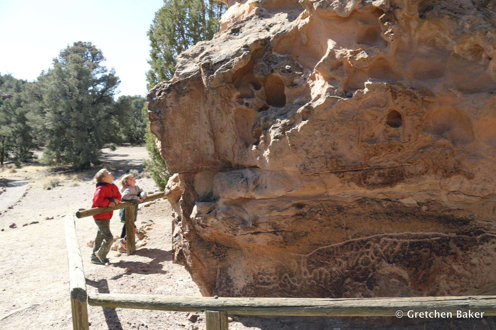
This may have been one of the cave entrances, they sort of blend together after awhile! It is such a fun place to explore, with cave entrances all over. The CCC improved trails in many of the lava tubes in the 1930s, making them relatively easy to walk in.


Some from our group went to the Western Regional business meeting. The kids climbed trees for a bit and then were ready to explore again. I wanted to show them the amazing Skull Cave, one of the few caves left with ice in it. About twelve have lost their ice in recent years.

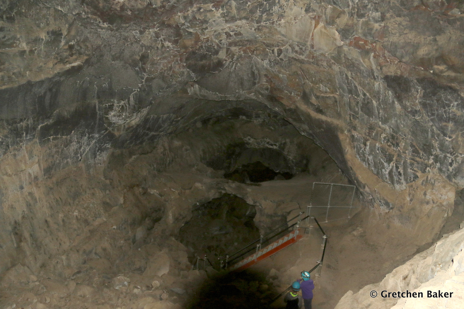
The entrance is immense.


And then the passage seems even bigger. Can you even see the kids?


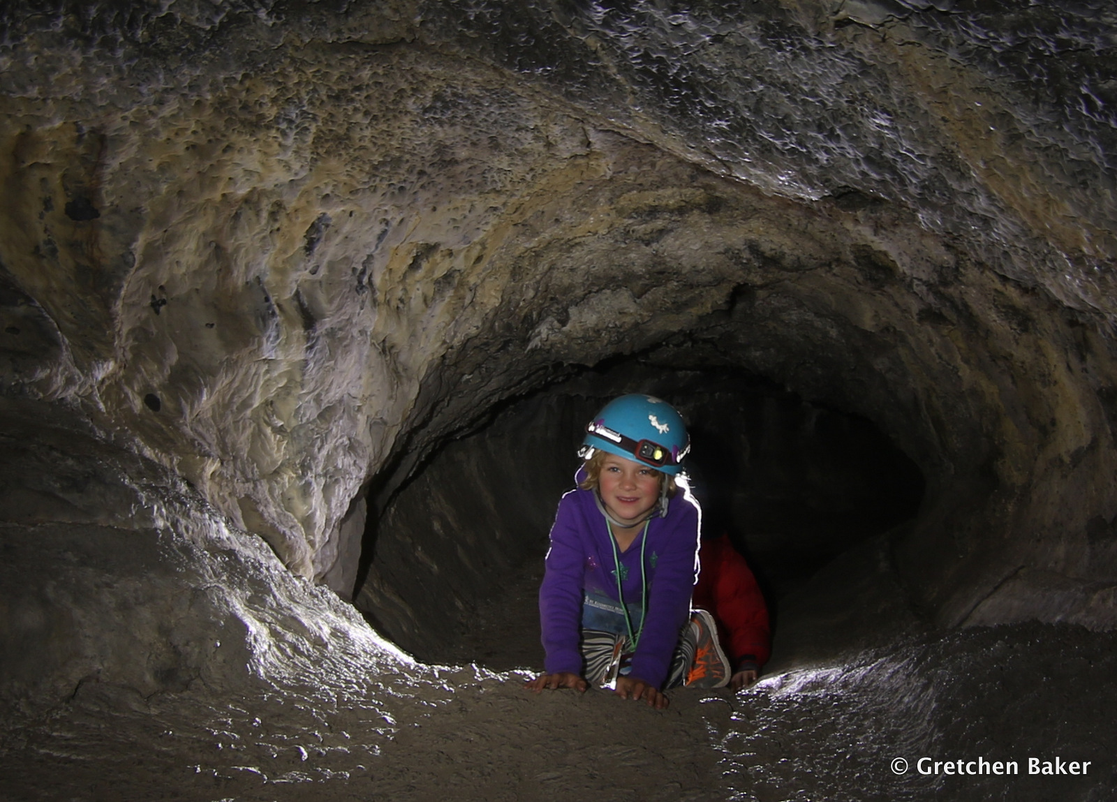
We went down steep staircases to get to the lower level.


And then we reached the gate. On the other side we could see the ice.

Although the ice in most of the lava tubes is shrinking, one resource manager told me that the ice in Skull Cave is actually increasing, and they don't know why. 


Next we headed further north, seeing so much more lava! We stopped at pretty much every scenic overlook to see what was there. Below we could see Schonchin Butte in the distance, and the Devil's Homestead Flow right in front of us. We also learned about the Modoc War, which started in 1872, when troops from Fort Klamath tried to force the Modoc from their tribal lands back to the reservation in Oregon. The Modoc hid in the lava. In April 1873 peace talks began, but they did not go well. The Modoc retaliated for the slaughter of 30 members of their tribe and killed two peace commissioners. For the next six months, 1,000 troops and volunteers sought to capture fewer than 60 Modoc warriors and their families. The Modoc were then sent to Oklahoma.


It was rather sad to contemplate that story, with the Modoc being forced off their lands. We found some peace at the West Wildlife Overlook, looking into Tule Lake National Wildlife Refuge. Thousands of birds dotted the water.

It was getting late in the day and the light was gorgeous.

As we came back to Schonchin Butte, we could see the fire tower in silhouette.

That night we had the big banquet, a delicious dinner put on by the Motherlode Grotto. Afterwards we intended to stay for some of the entertainment, but the cold temperatures and busy day had us heading to the tent.

I woke early and went for a lovely walk along the Bunchgrass Trail.

The sun came up and painted everything golden with the sun still in the sky.

Our plan for that day started with a Photography Trip with Dave Bunnell into Valentine Cave. When we arrived, a couple tripods were already set up near the entrance.

The kids offered to be models. But they quickly decided they'd rather be cave exploring!

So as we went through the cave, they posed, but not for long.

It was fun working with other photographers seeing how to place lights. Cave photography is all about the lighting.


But sometimes the best shot is happy kids in a cave!


We found a white springtail, which made me happy.


And then on to a few more photos.


The kids found that it was really fun to make shadow puppets on the lava tube walls.


Love all this walking passage!


They eventually got tired of the cave and we headed out. They weren't too interested in doing other caves, but they thought it would be fun to climb to the fire lookout, less than a mile each way.

The views were great, and we even got to see Mt. Shasta. It's so strange seeing a big volcano rising up covered in snow and ice. (It's barely visible in the photo below.)

We still had a little time before our 2 p.m. departure time, so we went over to Merrill Cave. It used to be an ice cave, and in fact there are photos of people ice skating on the ice. But it's all gone now.

The trail through the cave was very nice. 

The kids had completed their junior ranger booklets, so we went to the visitor center. Ranger Jillian swore them in.

We couldn't resist driving the 1.5-mile long cave loop one more time. And I might not have resisted a quick stop at Blue Grotto Cave. Which just happens to be a fairly long cave. And it was extra memorable when our lights started going out. 

It was a long drive, but Lava Beds was worth it. I would happily return, there is still so much more to see!

Sunday, October 22, 2017

Fairview Peak Earthquake Faults, Nevada

 Many times I've crossed Nevada on Highway 50 and east of Fallon seen the sign for "Earthquake Faults Six Miles" and an arrow pointing south. (Find it here on Google maps.) I've always been on a deadline and passed right by. But recently, we had a little extra time to spare, and I decided it was the day to go explore these earthquake faults.

Nevada has a long history of earthquakes. There are so many faults in the state (I'm speaking of the geologic variety here). The whole Basin and Range geologic province depends on faults for its interesting topography.

On December 16, 1954, a magnitude 7.2 earthquake rocked the Great Basin. It's epicenter was near Fairview Peak, east of Fallon. Two other large earthquakes had already occurred earlier in the year, and another one followed a few minutes later a bit to the north. The result was more than a 20-foot rise in mountains in some places! Very few people live in this area, otherwise it would surely have made big news. The earthquake was felt as far west as Sacramento, with plaster falling in the capitol building in Carson City, Nevada. Pictures rattled and chimneys cracked in Fallon, Eureka, and Austin, Nevada. Waterlines broke in Lovelock and Gabbs. But overall, there was not much damage for the size of these earthquakes.

We were in the van, which has very low clearance, but the sign said that we should make it. So we puttered off, enjoying our audiobook (We Are Legion: We Are Bob--fun listen, we recommend it). We followed the signs up a spur road, and it eventually got so steep we couldn't go any further. We were almost to the parking lot, and no one else was in the area, so we got out and hiked up to the displacement. It was really obvious, even 60+ years later!

There was a little trail going up, so we followed it. (You can see how close we got the van to the parking area--almost!)

Don't fall off! Oh my, it must have been something to have been in the area. You can see a great photo of a new cliff next to a cabin on the Nevada Bureau of Mines and Geology blog. It also mentions some of the stories about the earthquakes.

The Online Nevada Encyclopedia website mentions that the earthquakes opened up large cracks in roadways, allowed huge boulders to tumble onto roads, and substantially affected farmers' irrigation wells. It also mentions that although the 1906 San Francisco earthquake had just three feet of displacement, these earthquakes caused up to 20 feet of displacement, and the fault scarps were 54 miles long.

Another good account of a road trip is on this virtual trip. A fun story is on the Looking for Detachment blog.

If you're into the geology behind it all, check out this 1996 article in the Journal of Geophysical Research.

It doesn't take too long to walk along the earthquake scarp, so before long we were headed back to the van. I loved the golden rabbitbrush.

I had to stop again to take a photo of it and Fairview Peak. You can see the moon ready to set behind the peak, along with some communications towers on the top of it. About midway down there's a jagged scar showing more of the earthquake scarp.

We had gained some elevation so had a really nice view looking down towards the Chalk Mountains.

This detour was well worth the time. Just thinking about the immensity of these earthquakes--and that more will be happening within our lifetimes, and probably in more populated areas--makes you want to be prepared. Or be lucky enough to be outside in the boonies when the next big one hits!
p.s. If you'd like to spend more time in this area, check out The Great Highway 50 Rock Tour from Fallon to the Fairview Peak Earthquake Faults, with a number of stops along the way. We might have to go look for Nevada wonderstone on our next trip.

Tuesday, October 17, 2017

Hickison Petroglyph Recreation Area, Nevada

 Speeding along Highway 6 and 50 across the middle of Nevada at 70 mph, you see a sign for Hickison Petroglyphs Recreation Area and Interpretive Site. You've already been driving a long way from either Eureka or Austin, the two nearest towns, and it might be easy to continue on your way. But if you have a half hour (or more) to spare, it's well worth pulling over and checking this spot out. It takes you back to a much slower time.

About a quarter mile down a good gravel road is a parking area for the trailhead. You can pick up a very helpful trail guide and in just a couple minutes you're in front of petroglyphs.

The brochure says that the petroglyphs are typical of the Great Basin curvilinear style. The date they were carved and by whom is unknown. Unfortunately some dummies have vandalized the area, detracting from this old rock art. The horseshoe shapes are believed to be a female symbol.

 There are several panels of rock art along the cliff.

This panel has a lot of petroglyphs. The brochure says to note "the complex intersecting curved and straight lines." It does make you wonder what they were depicting!

 We took the spur out to the scenic overlook. It was so nice to stretch our legs. We often stop at the wonderful playground in Austin to do that, but this time we wanted to see something different.

 We were treated to some great views of the marvelous Great Basin. Nevada is the most mountainous state in the country, with over 300 mountain ranges. Traveling across the state means going over many mountain passes.

The kids had energy, so started running. It's getting harder to keep up with them!

We came to another wall with petroglyphs.

This rock art is very different from that found at Toquima Cave, which isn't that far away (at least by how the crow flies!).


We ended at a big boulder with more petroglyphs.


And, surprise! There's a little arch at the top of it.

This is a great place for a picnic, short walk, and there's even camping. But bring all the water you need, there is none available here. The kids enjoyed the stop and it was cool learning a little more about the history of the area.
Related Posts Plugin for WordPress, Blogger...

blogger templates