Tuesday, June 27, 2017

Looking for Evidence of Glaciers in Strawberry Creek

Last summer, the Strawberry Creek fire burned over 4,000 acres in and near Great Basin National Park, including up by the Strawberry Creek trailhead. My first time to visit it this year was to accompany glacial researchers Ben Laabs and Jeff Munroe to map the glacial features in the watershed as part of their project to make a glacial map for the park. We found that the vegetation was coming back nicely near the trailhead.

We headed up towards the Osceola Ditch, wearing hard hats to protect us from snags (well, at least from smaller falling branches, a hard hat wouldn't do much for a big tree!). It was hard finding the trail. Soon we left it and hiked up much higher.

As we walked, they pointed out different clues that the past glaciers had left behind, like glacial striations on rocks (where softer rocks got scraped by the harder rocks embedded in the ice), different kinds of rocks that had been deposited, and shape of rocks. The glaciers in the Strawberry Creek watershed had previously been mapped by Piegat in his 1980 doctoral dissertation, but he was covering a lot of ground and couldn't spend as much time as they were. These glaciers had formed up by Bald Mountain (the snow-covered peak in the photo below). The researchers found that it was much easier to read the land after the fire, as they could see more rocks.

Sometimes we got off on a tangent, like looking at the rock spalling next to this burnt tree. Basically the fire was so hot here that it burned the rock, causing the outer layers of it to fall off. Part of reconstructing the glacial history can include doing cosmogenic beryllium dating of moraine boulders, or taking a small piece of a boulder and dating it. If parts of the boulder are flaking off, the technique doesn't work so well.

I found one of the helispots still flagged from the fire. It's not flagged anymore.

As we hiked up and down the moraine, we spotted this huge ponderosa pine that had been spared. There were plenty of white fir ladder fuels near its base (smaller white fir trees that could extend the fire up into the ponderosa pine), so it got lucky.

We saw evidence of past logging in the watershed and wondered why the big ponderosa had been spared.

We found lots of elk droppings and found these scratches on an aspen.

Here and there was evidence of the forest recovering, like the elderberry below.


But the steep hillsides have not recovered.

Meadow areas look much better, with an array of wildflowers and grasses.

And wet areas are also coming back well.

We reached a section of trees that had speckled bark. I later learned that this is likely due to three-toed woodpecker activity in the area. They'll pull off bark looking for insects.

As we hiked down the moraine, we found small depressions, called kettles. These are from ice melting out. The remarkable thing is that these were on a very old moraine, over 100,000 years old, but are well preserved.

A view of the Osceola Ditch, a ditch made over a hundred years ago to transport water from streams around the mountain to the mining town of Osceola. The ditch didn't last long due to construction problems, water thievery, and the small amount of water available.

We had nice views of the meadow down below, and the scientists wondered if a small rise on the other side might be another moraine.

So we went down to check it out, passing some nice basin wild-rye on the way.

When we got to the rise, they found some good indications that it was a moraine. This extended the reach of the Strawberry Creek glaciers much further than had previously been mapped.

From our vantage point looking east, we could look back to where we had just hiked and see that 100,000+ year-old moraine (marked 'Moraine' in the photo). It slopes down to meet the creek. The wet meadows in the middle of the photo would have been covered with a thin layer of ice and be where this part of the glacier had met its demise.
It was an interesting day to not only see how things were recovering from the fire, but to also learn more about how to discover clues in the landscape that showed what had happened there in the past. The results from this study should be ready in a few months, and I'll be sure to post a link.

Monday, June 19, 2017

Snowy Ascent of Wheeler Peak, June 2017

I wanted to climb Wheeler Peak while it still had snow, but I didn't want it to take all day. My solution? Get up at 4 a.m. and start! I was at Stella Lake for a beautiful sunrise, and have to admit that I spent more than a few minutes taking photos.

Then I went around the lake and crossed this snow slope with crampons on. Except they weren't adjusted quite right, so I had some problems, and was slow.

When I got to a melted out patch, I found these interesting flowers. (And still haven't had time to look them up!)

Then it was on to more snow. The top of the couloir doesn't look that far, right?

Getting closer! I kept switchbacking up that gully for what seemed like a very, very long time. It was over 1,000 feet elevation gain.

The lake kept getting smaller and smaller. And I reminded myself that I would have a very fun time going down all this snow.

At the top of the couloir, it was time for rocks. The wind had blown most of the snow away. So I switched from my mountaineering boots to my approach shoes, which made it easy to go up the rest of the way.

I did find more snow at the very top.

But even there I found bare ground. I took a couple selfies to prove I was there.


Then I walked the ridge so I could enjoy the views. Here's looking south towards Baker Peak and Mount Washington.

And coming back, this is the ridge between Wheeler and Baker peaks.

I found the mailbox had been kind of crushed by falling rocks. I forced the door open and left my name in a little notebook.
Then it was time to head down. It was getting windier, and I even got blown down once.

The best part was the 1,000 foot glissade down the couloir. I kept my camera in my pack, though, as I wasn't sure how fast I would go and was holding on tight to my ice axe. It was so much fun going down.

I got down to the lake in good time and in great spirits. The early morning hike up the mountain was just what I needed. And hopefully that has helped acclimatize me for the season! It usually seems that the first mountain climb of the year is the hardest. It's now possible to climb the mountain with hardly any snow on the trail. Before long more flowers will be blooming, making the hike more colorful.

Friday, June 16, 2017

First 2017 Hike to Stella Lake, Great Basin National Park

 June rolled around, which meant that the temperatures were warming up and the kids didn't have school, so we could go on a fun hike. Jenny and I joined forces and took the kids up the Wheeler Peak Scenic Drive. We had heard that there wasn't much snow on the Summit Trail, which goes by Stella Lake, whereas the other high trails had lots of snow on them.

As we walked, I noticed the horizontal lines on this limber pine. What created them?
 If you guessed sapsucker, you're right. The woodpecker is looking for insects.

We still found some snow on the trail, along with aspen trees with teeny tiny leaves.

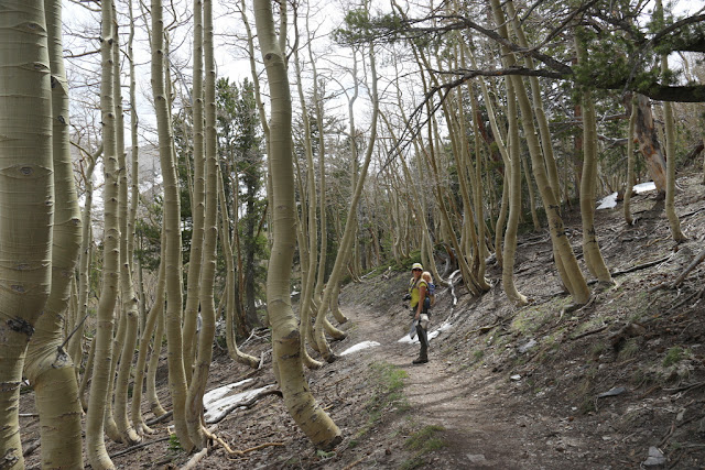
This is one of my favorite parts of the trail, it's like we're going through an aspen tunnel. The trees have bent trunks because of the weight of the snow pushing them down.

We emerged from the aspens to a meadow filled with snow buttercups.

One last snow drift to hike over...

...and then we were at the historic dam at Stella Lake. The dam was built back when the Osceola Ditch was being built (about 1890s) to increase the capacity of the lake and thus the ditch. I don't think it worked too well.

On the other side of the lake we saw where snow banks were collapsing into the lake.

Desert Boy wanted to make a raft out of logs.

Before long this progressed into Desert Girl testing out how waterproof her snow boots were.

She wasn't being the best role model for Willow.

But I don't think Willow cared.

The boys were trying out a potential boat. They all said that the water wasn't that cold. We reminded them that there was snow on the other side, but that didn't dissuade them.

Since it was a warm day, they kept playing in the water.

Even Ava, who wasn't feeling that great, got in on the action.

Desert Boy tried rowing his log. It didn't work out well.

Charlie was building a dock and the kids decided to bring some more logs over.

It was fun watching everyone just playing.

Although I was getting cold just watching Desert Boy!

Then he fell off.

The kids finally got cold on the hike back. Maybe the snow drifts finally made them realize that it's not quite summer at 10,400 feet?

Jenny asked for this photo in the meadow with Wheeler Peak in the background. Nice. I think it's going to be a summer with lots more hikes! Hurray!
Related Posts Plugin for WordPress, Blogger...

blogger templates