A little while ago we decided to take a trip up Lexington Canyon in the South Snake Range near Great Basin National Park to see what had happened since the Black Fire. The fire started July 1 and burned about 5,000 acres, with some of it getting a little exciting with big wind gusts that had firefighters calling for retardant drops and more than 100 firefighters. Other times the fire was quiet, burning slowly in high elevation forests. In late August we had quite a monsoonal pattern, with thunderstorms building and actually delivering rain nearly every day. Some of those rains were really heavy, including one over the fire that caused a flood washing many miles, out to the highway, with a wide debris path.
We stopped to take a look at the muddy wash bottom and were surprised just how wide and deep the water and debris had been.
We sent Desert Boy to the bottom of the wash for scale (and to run out some of his energy!)
He looks so small! Good thing this flood was in a place where no one lives.
We drove along the road, not really seeing much sign of the fire until we got to these burned cottonwoods.
That turned out to be the spot of a washed out culvert. It wasn't nearly large enough for all that water and debris washing through the channel.
The road was impassable at the culvert, but beyond it was in good shape (better than the Snake Creek road).
One of the things I was really interested in was what plants were coming back in the fire. These beautiful purple asters made an appearance.
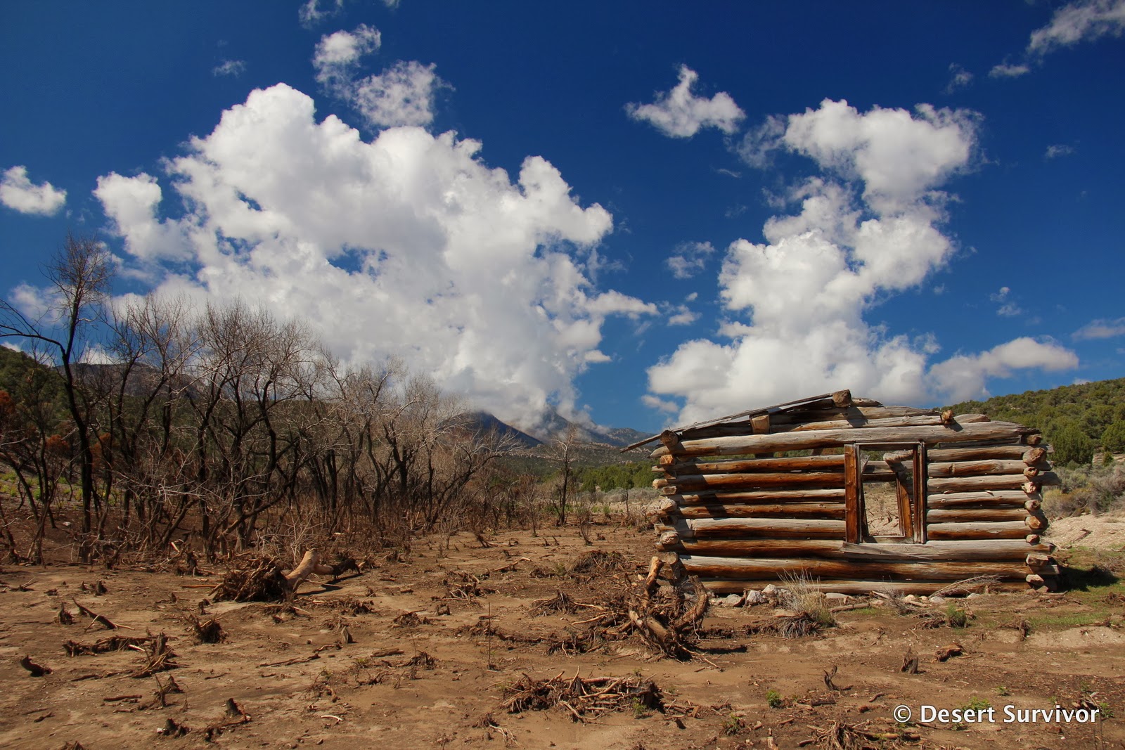
A little farther down the road we found the old cabin. This is where the Woodwards lived for a short time back in the late 1800s. They tried their hand at farming and helping with Quate's sawmill up Big Wash, but eventually left the area. I don't believe anyone has lived their since then, as it is quite remote, and over the years the creek eventually dried up.
The firefighters had saved the cabin by cutting most of the shrubs around it. This makes it quite accessible now.
It has no roof, but the old windows frame the view.
Nearby is the dry creek, with the dead cottonwoods sticking up like burnt matchsticks.
New cottonwoods are already making an appearance, and by next spring, this area will look a lot different.
We continued up the road, seeing how the fire had mainly stayed down in the lowest part of the canyon.
Farther up, we found willows growing.
We also found skunkbush (above) and rose.
As we neared the turnoff for Lexington Arch, we saw that the fire had climbed higher up the mountains.
The road was still in good condition, and we continued up to the spring, where we found a splash of green. We camped here in 2012, but it looked so different on this visit!
The insects loved a blooming dandelion!
The old trough was twisted even before the fire.
Here's a view of the spring and tank from the other side of the dry creek bed. The rock formations in the background really stand out now.
Mullein blooming.
Stinging nettles.
The spring still leaves puddles in the road!
Yarrow.
It looked a little more burned as we continued past the spring.
The fire was hot enough it even burned the rocks!
The road was in good shape till we reached where a side canyon met the main canyon. Then the washouts got more severe, and before long, the road had turned into the stream bed.
It was a strange feeling walking among all the dead trees--but it was easy walking.
I rather liked this saguaro-looking stump.
The power of the flood was evident in many places.
The kids weren't so excited about hiking, but we really wanted to get a view of the Arch, and we had already come this far.
We kept looking for interesting sights. We saw that the flood had transformed the landscape in so many ways. In the photo above, the flood washed away enough of the soil that the tree roots were exposed.
We took a little snack break and my husband took a couple photos so I could be in one!
I had been on this road to Lexington Arch several times, but I had never been very aware of the tiny creek bed next to it, mainly because it was almost always dry. Now the creek bed is wider than the road.
We walked in the creek bed for quite a ways, observing the tangle of roots in the banks.
A cool burned tree.
Rock lodged in the tree trunk.
Desert Boy's sad, "are we there yet" expression. Then he spotted something.
The trailhead sign! The sign still stands, although it burned and you can't read anything.
We all took a look at it. We couldn't see the trail right at that point, but it's in good shape further up the hill.
We found the road and hiked back on it (wasps were attracted to Desert Girl's sparkly shirt and were stinging her, so we took her shirt off and that solved the problem. We didn't have extra clothes and it was quite warm, so she was fine).

Whenever I see islands of green in a burnt forest, I wonder what influenced the fire so it didn't burn that spot.
I loved seeing this Indian paintbrush so far up the canyon!
And then we saw it, Lexington Arch! Looking at this photo really makes me want to hike up there and see how it looks up close.
It will probably be quite awhile (if ever) that the old trailhead is reestablished, but it's not that far from the end of the mostly decent road to the old trailhead.


1 comment:
Thanks for your account of the trail to Lexington Arch and the fire. I visited in October 2020 and could still of course see the devastating impact of the fire, but had no details about the fire. The road and trail remains washed out and is difficult to transgress, but totally worth the trek. The Arch is absolutely stunning, so glad I was able to see it. Best to you in your desert trekking!
Post a Comment