Showing posts sorted by relevance for query snow survey. Sort by date Show all posts

Monday, April 10, 2023

2023 April First Snow Survey


One of the winter field activities I enjoy helping with is the Natural Resources Conservation Service (NRCS) snow survey. It's been done in Baker Creek since 1942. You can see some of my previous posts about it in 2011,  20122013, 2014, 2015 (March)2015 (April), 2016, and  2019

Thankfully Great Basin National park maintenance was able to plow to the Baker Creek Campground, where we found conditions pictured above.

We put on our skis and started up. Often we see marmots at the end of March, but not this year!


Three of us were headed up to 9500 feet for this snow survey.

At the Baker Creek trailhead, we found the outhouse about half buried in snow.

The route to the first snow survey was covered in snow, with not even any bushes showing. 

Contrast that with the view of the 2014 snow survey, where we had to figure out a way around all the sagebrush and rabbitbrush. The 8000 foot elevation sign was prominently showing.


We measured the snow at the first site and found we were standing at the top of the snow survey signs.

That's in big contrast to 2015, where there was bare ground at some of the signs!

For much of our ski, we were high up next to the trees. We skied right over most obstacles, but did find a few things a challenge.


We marveled at how the aspen inscriptions were partially covered in snow.

At the second site we used four sections of snow tube. Each section is 30 inches long. We had one measurement over 90 inches! Yikes!

Weighing the tube took some balance. The snow tubes are calibrated so that when you weigh the tube and subtract the tare (the weight of the empty tube), you get the Snow Water Equivalent, or the amount of water that is covering the ground if all the snow was suddenly to melt. We measured over two feet at the second site, at 9200 feet. We found that the snow depth was the highest ever measured, beating a 1952 record, and the Snow Water Equivalent was the second highest in the 81-year record.

We were at the top of the snow marker! We had to get a shot of all of us up there.

Here's a view of the same sign in 2014.

We continued up to the third site, and I marveled that we could neither see nor hear Baker Creek. It was so covered in snow. The photo below is where a spring starts on the hillside and flows into the creek. No sign of it either.

Meg was also delighted for such an epic ski day. It was sunny and mostly calm.

In places the snow was piled high on branches.


We were wearing avalanche beacons, just in case. The only place where we've seen evidence of an avalanche is in this aspen area.

In 2005, the avalanche came down the chute, across the creek, and up on the other side. We kept moving.

As we approached the third site, I again marveled at how covered the springs were.

An indentation was all that showed where the spring brook ran.

We got to the third site and found the sign just sticking out of the snow!

This relaxed pose ended up in the NRCS Snow Report!

For contrast, here's the same sign in 2015.

We started out by taring the tube, or weighing the empty snow tube.

And when the ten-foot long pole (120 inches) was put down into the snow, this is all that remained above the snow. Yikes! It turned out to be another snow depth record and third highest SWE record.

We couldn't even see the orange aerial marker, it was completely buried (photo below from 2014).


The ski down was easier than most years, as there were very few obstacles. We didn't have to take off our skis to get over snow-free patches.

It was a treat to see what truly epic snow conditions on the mountain are. 

The data we collected are synthesized into the NRCS Water Supply Outlook Report. You can find that and lots more on the NRCS Nevada Snow Page.

Monday, May 12, 2014

Snow Survey 2014

We woke up yesterday to fresh snow in the mountains, and it reminded me of the snow survey I did the end of March that I never posted.

Snow surveys are conducted throughout the western U.S. to help predict stream flows. The Natural Resource Conservation Service, an agency of the U.S. Department of Agriculture, runs the program. In Great Basin National Park, three snow courses are found along Baker Creek. They were established in 1942 (when the land was managed by the U.S. Forest Service), and almost every year a snow survey is conducted at the end of February and the end of March.

Mark and I started near the Baker Creek campground on a snowy morning on April 1, the last day we could do it to be in time for the April 1 forecast.

By the time we walked/skiied up to the trailhead at 8,000 feet, the precipitation had stopped. But there was barely enough snow to ski on, and soon we were walking again.

Fortunately after the first site at 8250 ft, we found some nice snow. The sun came out, making a beautiful day. When I first started doing the snow survey about three years ago, it seemed so long. Now it just seems like a pleasant outing. (I still am sore at the end of the day, though!)

A smile from Mark, despite the skis picking up too much snow. It was right around freezing, and the snow was sticky.

The second site is usually cold because it's shady and down near the creek. This year it didn't seem too bad. At each snow course we took five measurements.

Here's Mark getting the tube ready to push into the snow. How far down will it go?

We measured the snow depth, how much snow was in the tube, and then weighed the tube to get the snow water equivalent, or how much water is in the snow. That's the most important measurement for forecasting.

I couldn't help but snap a few photos on the way up to the third site. The snow was deep enough to make some interesting patterns right near the creek.

It's a really cool feeling making fresh tracks in fresh snow. It had snowed the night before, and the trees still had lots of snow on them.

This slope had a huge avalanche in 2005 that went all the way down the side of the mountain, across the creek, and part way up the other side. I'm always fascinated to see who the vegetation is growing.

Finally we made it to the third site. This is the prettiest site, a large meadow. I could hang out here for a couple hours.

This site has an extra orange marker, which is an aerial marker. In the old days, a plane would fly by and an observer would get an estimate of snow depth by how much snow covered the marker. Today the NRCS has installed a network of Snotel sites that give them much more accurate information than the fly-by method.

Once we completed all the measurements, we headed back down the trail. The snow was melting faster, and we had some extra rocks to traverse. It was not the easy downhill we were hoping for.

And then the snow ran out. We had to take off our skis and hike. Boo.

We were really hoping that someone would have opened the gate and driven our vehicle for us up to the trailhead, but no such luck. We still had more hiking to do.

The silver lining is that we got to see a couple marmots! They were actually seen in late February this year.

It's cool to have such a long dataset to see how the snow depths and snow water equivalents have fluctuated over the years. Over the whole period, there is a slight downward trend, even though the overall precipitation record shows a slight increase. This indicates that we are getting more snow as rain than snow, which changes the timing for peak stream flow and how much water is stored as snow into later into the summer. Looks like times are a'changing!

Here's what the snow survey looked like in 2013 and 2012.

Wednesday, February 27, 2013

Snow Survey 2013

The last week of February is the time to do the snow survey for the March 1st forecast. I was sort of looking forward to it, as the scenery is beautiful, but I was also sort of dreading it, as it's a really long day and I haven't been cross-country skiing since last winter.

 We met at the road closure at 7 am, which meant for an earlier start and a more likely finish before sunset. Last year we ended by skiing in moonlight, and we didn't want a repeat of that.
The first mile and a half was along the road with two inches of snow, and often times less. It was a little frustrating not to be able to drive up the road, as the snow was so low. We were wondering if the whole day would be with so little snow. We saw lots of bare ground and signs of spring--many birds singing (mountain chickadees, Cassin's finches, dark-eyed juncos, common ravens, northern flickers, nuthatches, kinglets, and more). John told me that when he had skied up the day before, he had seen marmots at the marmot crossing sign. Wow, marmots in February! With the are south-facing slope bare of snow, they apparently can find some food.

 We didn't see marmot tracks, but we did see lots of rabbit tracks and a fox that meandered back and forth across the road several times. When we saw the two tracks next to each other (above, rabbit on left, fox on right), I wondered how much time separated them.

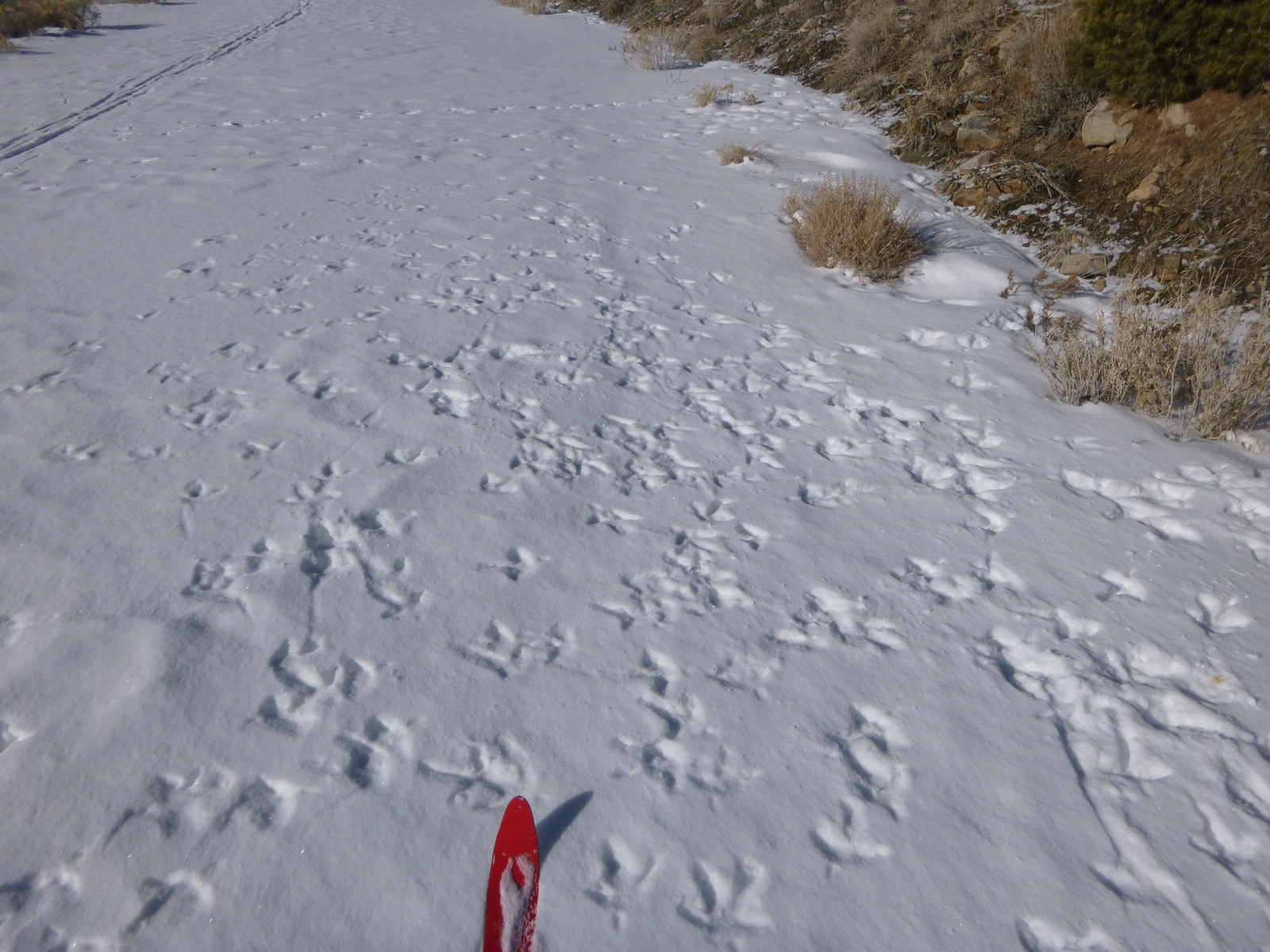
 We also found where a bunch of turkeys had crossed the road. They have spread all over the park, and this wouldn't be the only time we saw evidence of them.


We reached the first of the three snow survey sites after a little more than two hours. During the summer it's about a five to ten minute walk from the trailhead. The snow survey sites were established in 1942 by the predecessor of the Natural Resource Conservation Service (NRCS). These sites, part of a large network in the West, help the NRCS predict how much water will be in streams in the summer. Many of the snow survey sites have been automated, and the 10-mile round trip we were doing is one of the last, long courses left.

It only takes about 20-30 minutes to do the actual snow measuring at each snow course site. The basic procedure is to use a special metal tube to measure snow depth and then weigh the snow in it. This is done five times at preset distances from the snow course markers. The average is computed and compared to previous years. The first site had roughly 50 percent of average for the snow water equivalent (SWE), which is a nice way of saying how much water is in the snow. We hoped the upper two sites would be a little more positive.

Five of us started the snow survey, but one member turned back after the first site. He may have known what was to come:
 Deep powder, sometimes up to our knees. It made trail blazing a real chore. We took turns leading, but none of us could go for very long because it was so taxing. People who love to ski powder must not spend much time going uphill in powder. And we had a lot of uphill to go--2,600 feet.

 Here's a view I had at one point while I was leading--fresh snow with cool shadows. The scenery was beautiful, but it was hard to think about it sometimes, as we were gasping for air.

 What was frustrating was that even though we were in deep powder, up higher on the hill all the snow had melt off. It was such a teaser!

 We also had some obstacle skiing, like going over deadfall and under logs.

 About lunch time we found a melted out spot and sat down for a few minutes. That 15 minutes was the only time during the ten hours that we got to sit. Mark couldn't get one ski off, and I couldn't get either off, due to the bindings freezing up. So we felt a little stuck. The temperature hovered near freezing, which meant that I got chilled relatively quickly and set off for Snow Course Site #2.

 Snow Course #2 down in the trees and cold and snowy. After we finished that site, one member decided to head back and wait at the lunch spot. He was just a little too worn out due to the elevation and exertion. The remaining three of us headed on to the last site.

 One thing that's good about getting way up there is that the views keep getting better. This area is so pristine, and I love the feeling of being out in the wild. Realizing that if any of us needed a rescue that we would have a very long wait makes it feel even more raw and makes me feel more alive. We carried a SPOT device and checked in regularly.

 I kept on the lookout for winter beauty, like the snow melt circles around the aspen trees.

 And a Douglas fir cone that had rolled down the slope, creating its own little trail.

 The pure winter light made the limber pine needles stand out in the shadows.

 Here comes Ben.

 Then at about 9,500 feet, we saw some animal tracks. We had seen hardly any animal tracks above 8,000 feet, so we were surprised. What was out and about? It didn't take long to see the three-toed tracks and some wing brushes in the snow. A turkey had been up here. They are non-native, so we're none too pleased to see their evidence.

 Finally, about 2 pm, we made it to the third snow course site at 9,600 feet. It's in a meadow longer than a football field.

 Here I am, with my pack creating a strange silhouette.

 Ben takes one of the snow samples, pushing the metal pipe through the snow until it reaches the ground. We found lots of mud under the snow.

Then the snow was weighed while I took notes. Both the second and third sites had roughly 70-75% of average SWE. We need more snow!

When we finished the fieldwork, it was time to head down the mountain. I fell several times, but the powder provided a soft landing. Getting back up was not easy, though. By the time we got back to the truck, I was thoroughly exhausted. Ten hours on skis does that to a person!

We have a photo in our house of my husband's grandfather helping with the snow survey decades ago. He and the group are all on snowshoes. I wonder how long it took them to do the snow surveys, and think of all the untold stories of these annual winter forays up the mountain in search of snow measurements.
Related Posts Plugin for WordPress, Blogger...

blogger templates