Showing posts with label camping. Show all posts

Saturday, September 14, 2024

Family Backpack up Strawberry Creek, Great Basin National Park

Last weekend we went for a little family backpacking trip up Strawberry Creek. The trail up to the saddle is not well used.

I really enjoyed the arborglyphs like this one, which said "Peligro" (Danger) and had a skull and crossbones. What danger lurked ahead? Many of the abundant arborglyphs were carved by longely sheepherders from Peru in the 1980s. Nowadays the practice is frowned upon because it damages the aspen trees.


It didn't take too long to get up to the saddle area (with Willard Creek), and to my surprise, some of the aspens are changing color already.

There's a large spring in the area.


This old sign is tacked onto a nearby tree. I think it was from when the area was managed by the Forest Service, so prior to 1986.

I was so excited to enjoy the view during golden hour, and fortunately Desert Girl was willing to pose.

We heard one bull elk bugling, which is such a weird sound. But it was pretty quiet during the night, much to my surprise. I woke up early.


And enjoyed sunrise.

Clouds always make the sky prettier!


The views in this area are really pretty. Perhaps not stunning like in some nearby spots, but just a gentle beauty and peace that is very comforting.

A cow skull from days gone by is on a boulder. Cattle grazing was retired from Great Basin National Park in 1999 and sheep grazing in 2009.


This arborglyph is a bit of a map, with an arrow towards Osceola and the Robison Spring. The Robisons lived in the area for a long time and ran a lot of sheep on the Snake Range.

Hiking down the next day we saw this arborglyph from 1911. I can't really figure out what else it says.


And here's one from Cepari Palomo (who also signed a lot of trees as Palomino). Part of it says El Muchacho Universitario (the university boy), Electrosta...Ley de Coulomb (electricity...Coulomb's Law). 

My husband and Desert Boy stop for an older arborglyph.

This one that says H2O and an arrow shows where Strawberry Creek reappears and then continues flowing.


And here's an arborglyph from 1903!

We saw a couple elk wallows. Generally a large herd of elk congregate in Strawberry Creek in the fall. When they bugle, it's an amazing sound.

The elderberries were ripe, so I snacked on them.

And then we finished the hike back through the burned area. 

I don't have many photos of backpacking because the kids were so fast. I was the caboose. It was fun to go see a different area and have a short amount of miles to cover! 

Sunday, May 1, 2022

Hanging out with National Geographic

Last summer I had the chance to show a National Geographic writer a part of Great Basin National Park, along with research scientist Dr. Anna Schoettle. We went up Mt. Washington to look at bristlecone pines and discuss White Pine Blister Rust. My job was basically as driver and tour guide, so we stopped at one of my favorite overlooks.

Later, we went up high on the mountain, where we saw some small trees making a start at life.

We also looked at some old bristlecone wood, left from when the bristlecones died off the last time it got cooler and trees moved back down the mountain. Dr. Schoettle discussed some of the new threats these long-living trees face, like white pine blister rust, a non-native pathogen that has had a devastating effect on lodgepole pines in nearby Montana. We also discussed climate change, wildfires, and beetles. Fortunately, the trees in Great Basin National Park look to be okay at the moment, although it's hard to predict how they will do with the fast-moving climate change we're currently experiencing and the many consequences it has, such as more extreme weather events.

Craig Welch is a staff writer for National Geographic and was starting research on a story about forests in peril all over the world. He told us we might only see a paragraph in the whole story about bristlecones as he had so much material to cover. The article would be appearing in May 2022 in a special issue about trees. He enjoyed his trip and kept saying if he had known how stunning it was, he would have brought a photographer with him. 

Fast forward to September, and I was driving a National Geographic photography crew up the mountain for an overnight to capture photos of the area. I had been feeling kind of blah about photography, so was looking forward to being with some experts.

I was immediately impressed by their enthusiasm and abundant photo and video taking.

They made me slow down and take a closer look at bristlecone pine cones (love those bristles!).

And the male pollen cones.

The 2000 Philips Ranch wildfire that burned over one thousand acres included bristlecones, making for some dramatic scenery.

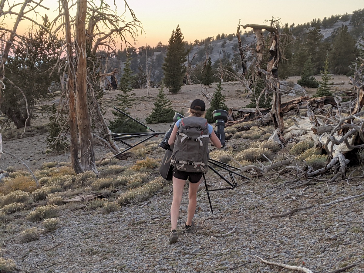
Another thing that impressed me was the vast amount of gear they hauled everywhere. The main photographer was Keith Ladzinski, world-renowned. His assistant Angie Payne (a great photographer in her own right) was a pro at anticipating needs and lugging the heavy bags. Videographer Tommy Joyce kept his camera rolling.

While I observed, I mainly tried to stay out of the way. I couldn't resist snapping a few photos myself.

September was a great time with the fall colors (the far-off aspen patch is one of my favorites!). And spending the night was a good call so we could enjoy golden hour.

I find that I particularly enjoy patterns.

Here's Keith checking a photo he just took.

More patterns. (Did you say squirrel? lol)

The burned trees made for interesting shapes and textures.

Here's Angie carrying tripods and lights. I learned a lot about how much they use additional lighting. 

We talked about bristlecones and their life cycles. This bristlecone is so much older than Angie, even though it's just barely taller than her.

As the sun set, we saw beautiful colors to the west.

The crescent moon hung in the sky.

Then it was time for sleep. Sort of. There were cameras going all night, and then we got up very early to go hike down to the "magic grove" of bristlecones to be there before sunrise. We needed our headlamps.

Unfortunately, it wasn't a cloudy morning, so we didn't get the most dramatic backgrounds, but just before sunrise was quite nice.

Plus, I just love this tree!

So, it's now May 2022. What about that special National Geographic issue? They sent me an advance copy for helping out. 

There's a gorgeous shot by Keith and a paragraph of info. In fact, it might be the most hopeful paragraph in the whole section! The article is amazing, Craig made it seem effortless to combine personal experiences with facts about complex issues. I heartily recommend picking up a copy.


You can also find the story online with a bonus timelapse of bristlecones in Great Basin National Park (and some other trees in other areas):

Forests are reeling from climate change—but the future isn’t lost (nationalgeographic.com)

It was such a great experience helping out the National Geographic crews. It is truly amazing how much work goes into every photo, article, and video. Hope you enjoyed this little behind-the-scenes look!

Monday, June 15, 2020

What to Do at Great Basin National Park during Covid-19

Wheeler Peak and Doso Doyabi at Sunset, as seen from the Scenic Drive

The status of Great Basin National Park is changing frequently. For the most up-to-date information, see the Park website.

This blog post is intended to help those trying to figure out what to do during a park visit, especially since the visitor centers are currently closed. As of June 15, 2020:
  • The roads and trails and most campgrounds are open except
    • Wheeler Peak Scenic Drive Will be closed from June 29 through July 2nd 
    • Update: on 7/1, the park announced the Drive will also be closed July 7-10
  • The only paved road in the park is to the Lehman Caves Visitor Center and the Wheeler Peak Scenic Drive.
  • Wheeler Peak Campground will not open this summer, as it is being renovated.
  • Great Basin Visitor Center will open soon, possibly June 26.
  • Lehman Caves Visitor Center and Lehman Caves are likely to be closed for the summer. It's a little ironic, as the Lehman Caves Visitor Center got new, cool interactive exhibits in February. Want to see the cave? Here's a short video that shows more about caves and cave research in the Park.
    Short video about Cave Research in the Park
1. Where to stay?
If you're camping, you have lots of options. Camping in the park for tents and small RVs is available in Lower Lehman (best spots for RVs), Upper Lehman (spacious campsites), Baker Creek (often last campground to fill), Grey Cliffs (only 1.5 miles from main road, but not much shade), and Snake Creek (dispersed and no potable water, but free). Campsites often fill by 2 pm on weekdays, earlier on weekends. (Where to camp if the park campgrounds are full.) No hook ups in the park. If you have a big RV (longer than 24-30 feet), the park campsites probably won't accommodate you, but the Whispering Elms in Baker has beautiful sites, and there are also RV sites at the Border Inn and Baker Fuel and RV. A variety of motel and Air B&B options are available at discovergreatbasin.com. Some folks will also stay in Ely, Delta, or Milford and come for a day trip.
Camping under the Milky Way

Where to eat?
Bring your own food or enjoy eating out. Right now, here's what's open (with more details at discovergreatbasin.com):
  • Border Inn, on Highway 6 & 50 at stateline, kitchen open daily from 6 am to 10 pm (breakfast, lunch, dinner)
  • Great Basin Cafe, next to Lehman Caves Visitor Center, daily from 8 am to 5 pm (breakfast, lunch)
  • Baker Bean Coffee Cart, downtown Baker, daily from 7 am to 3 pm (breakfast, lunch, coffee and baked goods)
  • Kerouac's, downtown Baker, 4 pm to 8 pm (dinner), closed Tuesdays and Wednesdays
Convenience stores are also located at the Border Inn, Kerouac's, and Great Basin Cafe.

What to do?
1. Ancient bristlecones. If you've never seen old bristlecone pines, old meaning more than 3,000 years old, this is your chance. Drive 12 miles up the Wheeler Peak Scenic Drive to the end of the road at the Bristlecone trailhead. Then plan for about an hour-long hike over a rocky trail at over 10,000 feet elevation to an amazing grove in the shadow of Wheeler Peak. Allow 30 minutes for the drive each way, plus 2-3 hours for the hike. You can hike beyond the grove to the rock glacier, add 0.5-2 hours depending on how far you go. Note that the parking area is starting to fill from about 10 am to 3 pm, so consider earlier or later, when the light is better and parking more abundant.
Hike to Wheeler cirque bristlecone grove in Great Basin National Park
Wheeler cirque rock glacier at 10,800 feet. There is still ice under the rocky shroud, at least in the upper portions of the rock glacier. A tiny real glacier is found along the headwall.

2. Cool off at higher elevations. Also at the end of the Scenic Drive is the Alpine Lakes Loop. This is a charming two-hour hike that visits Teresa and Stella Lakes. Take your time and soak in the cooler temperatures. Watch out for afternoon thunderstorms, high winds, and elevation sickness. The reward is amazing views. You can combine this with the bristlecone pine hike for a lovely longer hike.
Stella Lake at sunrise

3. Beautiful hikes. Great Basin National Park is a hiking park. The two trails mentioned above are relatively busy, but most of the others don't have much traffic!

3a. Short trails (approx. 30 minutes to 1 hour):
  • Mountain View Nature Trail behind Lehman Caves Visitor Center--through pinyon/juniper forest for 1/4 mile;
  • Sky Islands Forest Trail-Accessible trail at Bristlecone trailhead--through Engelmann spruce/limber pine forest for 1/4 mile, wheelchair accessible
  • Strawberry Sagebrush Loop Trail: 1+ mile loop that lets you look at how the landscape is recovering after the 2016 Strawberry fire
  • Start any of these other trails listed below and turn around when you want
3b. Medium trails (2-4 hours)
  • South Fork Baker/Baker Lake loop: 3.5 mile loop, steep in places, but gorgeous, follows riparian areas
  • Serviceberry Trail: 3+ mile loop along Snake Creek road with a variety of habitats
  • Lexington Arch: 6+ mile round-trip hike to a huge natural bridge; dogs allowed (here's more about the canyon)
  • Osceola Ditch Trail: 1.5 miles to Mill Creek, 5 miles to Strawberry Creek trailhead, steep for first 0.3 mile, then the the flattest trail in the park, follows old water ditch and goes through 2016 burn
  • Bristlecone/Alpine Loops trails mentioned above

3c. Long trails (>3 hours)
  • South Fork Baker/Timber Creek loop: 5.5 miles but lots of elevation change, two beautiful meadows
  • Dead Lake: a new trail from the end of the Snake Creek road heads to this often-overlooked lake, and you can make a loop trail of it
  • Wheeler Peak summit: the trail is 4-miles one way, but gains 3,000 feet elevation. Many people underestimate the effort it will take. Plan on 3-4 hours to summit, some time at the top, and 2-3 hours to get back down. Take plenty of water and food and be prepared for big winds. Stay off if storms are looming.
  • Shoshone/North Fork Big Wash: If you want a trail to yourself, start at the end of the Snake Creek Road and head up and over into the next drainage. Seldom visited, some bushwhacking required.

4. Backpacking.
  • Baker/Johnson loop: this is a classic. Start at the Baker Creek or Snake Creek trailheads. About 13 miles round trip with lots of elevation change. Camp at Baker or Johnson Lakes. No campfires above 10,000 feet.
  • South Fork Baker/Timber Creek loop: This loop is only about 5.5 miles, but lots of elevation change. Good for beginning backpackers and families.
  • Johnson Lake/Snake Ridge Divide loop: This is for the advanced, as you have to scramble along a ridge with no trail.

5. Animal Watching.
  • Yellow-bellied marmots. From May to about July, it's often possible to find yellow-bellied marmots along the Baker Creek road. You'll see the marmot crossing signs--these cute animals aren't the smartest, so slow down to keep them safe!
  • Rocky mountain elk are seen most frequently in the Strawberry Creek drainage. They are much larger than deer.
  • Bird-watching is excellent along Strawberry Creek, where you can find lots of cavity nesters like mountain bluebirds, hairy woodpeckers, house wrens, and mountain chickadees. Baker Creek area has lots of riparian birds like warbling vireos, MacGillivray's warblers, yellow warblers, lazuli buntings, and more.
  • Fishing. With a state permit, fishing is allowed in the park. Native Bonneville cutthroat trout are in South Fork Baker, Snake, and Mill creeks (catch-and-release recommended as the Park is trying to restore these populations). Brown, rainbow, and brook are in Baker and Lehman Creeks.

6. Check out the Dark Night Skies. If you're camping, your campsite might be a great place. Another recommended place is Mather Overlook. You will see the Milky Way best during and near the New Moon (in 2020: June 21, July 20, Aug 19, Sept 17, Oct 16).
Milky Way from Mather Overlook


7. Other Nearby Places Worth Visiting

Baker Archeological Site - visit the townsite of a Fremont village, occupied from 1220 to 1295. It's about 2 miles from Baker, and a guided booklet tells you about the site and how the buildings were arranged. This is a good place to picnic, with covered picnic tables.
    • Baker Archeological site

    Sacramento Pass Recreational Area
    : Camping, fishing, plus mountain biking and hiking on a seven-mile trail system. Only 15 minutes from Baker.
      Sac Pass fishing pond
Crystal Ball Cave: Although Lehman Caves isn't open, Crystal Ball Cave, 30 miles north of the Border Inn, is open by reservation only. This is a terrific cave, it feels like walking through a giant geode. It also is the site of amazing paleontological resources. Cave website (keep in mind that it's located in mountain time zone and takes about 45-60 minutes to get there from Baker)

Crystal Peak is a cool volcanic mountain located about an hour from Baker. You can see it gleaming in the afternoon sunlight from Highway 6 and 50, and also from high points along the Scenic Drive.


Those are just a few suggestions, click on the links to see additional information. If you'd like more, Read my book! It is full of natural and cultural history of the area, places to visit, and more.
Related Posts Plugin for WordPress, Blogger...

blogger templates