Tuesday, June 17, 2025

Sub-alpine Lakes Loop and Bristlecone Trails, Great Basin National Park

We had family in town, it was the end of May, and it was time to check out some of the higher elevation trails! With only about 65% snowpack for the 2024-2025 winter, the Wheeler Peak Scenic Drive opened just before Memorial Day weekend, allowing easier access to the snowy trails.

We started in the parking lot with some silliness.

Then it was time for the before photo. We were prepared with hiking poles and microspikes for most. Footwear and clothing varied.

This stump chair is always a favorite!

We found a lot of snow on the trail to Stella Lake.

 Fortunately the snow lessened as we got on more south-facing slopes.

I was surprised to see so much ice still on the lake. The snow above it looked patchy.

The trail between Stella and Teresa Lakes was about 60% covered in snow. Fortunately someone who knew what they were doing made the first tracks, which lined up with the orange trail markers on the trees.

When we got to Teresa Lake, we saw that it was about double the size from a few days previous, but still small. The inlet stream was barely flowing.

Then our group split, with some going on to the bristlecones. The north-facing slope was quite treacherous.

My nephew fell, but fortunately stayed on the trail. And he even smiled!

When we turned the corner, the conditions improved a lot, and soon we were in the bristleone grove, admiring these old beings.


And why not give the tree a hug?


I also encouraged touching the bottlebrush-like needles. They feel so nice.

It was definitely good we had microspikes this early in the season. A couple weeks later and they weren't needed. 

The Bristlecone Trail and Sub-alpine Lakes Loop are two of the busiest trails in the park, and for good reason, they are beautiful. Fortunately, Great Basin National Park doesn't have super high visitation, so you can still have a true national park experience. However, parking is limited, and on weekends and holidays, it's best to arrive before 9:30 am or after 3:30 pm to snag a parking spot.

Sunday, June 15, 2025

Sage Steppe Loop and Old Osceola Trail, Strawberry Creek, GBNP

It's great to have family visit, because it's a good excuse to get out hiking! For an easy morning hike, we headed over to Strawberry Creek. We were hoping to see some elk or deer on the drive up the scenic canyon road. Alas, they were somewhere else, but we did see something we stopped for:

A Great Basin rattlesnake! And it was in the middle of its breakfast, complete with a mouse tail protruding from its mouth. This was so cool. It only had a handful of rattles, so this was a rather young snake.

It moved off the road into some Oregon grape and sagebrush, and we left it in peace.

When we got to the trailhead, we were the only vehicle. We started off on the 1.2-mile long sage steppe tour to the left to go clockwise. The trail quickly enters a burned area.


The kids seem to appreciate extra challenges, which I was happy to give them.

We took a little break at the bridge at the top of the loop.

Just beyond is a trail junction sign. If you go left, you are on the old Osceola Trail heading to the collapsed tunnel and Weaver Creek. I had never taken the trail before, and the rest of the group was amenable to giving it a try.

The trail was easy to follow, being in a ditch. Even though the ditch is more than a hundred years old, it's still a ditch. Until you get to the end, when it just suddenly ends. This is where the tunnel would have been, but it's so thoroughly collapsed, you don't get much sense that there had been a tunnel.

Instead of heading back down the ditch to reconnect to the Sage steppe loop, we decided to head cross country. Under this tree we found piles of fence posts.

We had to zig and zag to avoid some of the taller veg, but eventually we made it back to the trail.

And there was enough energy for one more challenge!

I highly recommend the Sage steppe loop. It's a neat view of a burned area, is short and not too steep, and during the summer has lots of flowers blooming.

The Osceola tunnel trail is one that can be skipped. There is not much to recommend it.

Sunday, June 1, 2025

Snake Creek Overlook Trail, Great Basin National Park

With family in town and ready to stretch their legs, we headed up Snake Creek. At first we thought we would do the Serviceberry Loop trail, but decided we didn't have enough time. So we started on the Snake Creek Overlook trail (highlighted in orange on the map), a trail I wasn't familiar with.

It starts at the end of the Snake Creek road, on the same trailhead as Dead Lake. It's a lollipop hike, with a straightaway, then a loop, and then back to the straightaway to return.

The trail veers off from the Dead Lake trail and crosses the creek to go to a couple walk-in campsites, which were occupied.

There are even picnic tables and fire grates at the walk-in sites.

We finally remembered to do a "before" shot.

We followed an old road up to a sign that showed we were at the loop section. We didn't know if there was a better direction to go, so we arbitrarily went left.

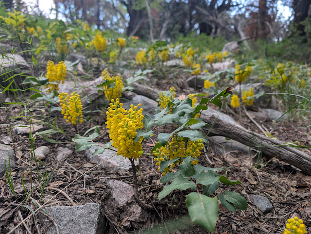
Lots of Oregon grape aka creeping mahonia (Mahonia repens) was blooming.

At the top of the loop is this huge dead ponderosa pine. Some live ponderosa pines are nearby. 

We thought the overlook would be at the top, but didn't see anything, so we started hiking down.

Then we found a bench with a glimpse of Pyramid Peak.

From here, the trail was back to an old road, so was more gradual.

I enjoyed seeing the manzanita (Arctostaphylos patula) blooms.

Desert Boy is going to be doing an internship at Great Basin National Park this summer, so I thought it might be good to see what he knows. Could he match the foliage with the pinecone?

Do you know what each of these pinecones/foliage are? Answers under the photo.
From left to right: ponderosa pine (Pinus ponderosa), Douglas fir (Pseudotsuga menziesii), white fir (Abies concolor).

Here's the white fir closeup, with grayish-green needles and rather smooth bark on the trees.

And here's Douglas fir, with a darker green needles and flakier bark.

While Desert Boy was puzzling it out, I noticed a different looking tree nearby. It's a bristlecone pine (Pinus longevae)!

Then it was back to the parking lot, which has some nice views of the limestone Eagle Peak.

The short hike was just what we needed to stretch our legs and see a couple interesting sites. This would not be a hike I would recommend as a destination hike, but it's fine if you have some extra time and are looking for something off the beaten path. Or if you are trying to hike all the trails in the Park this year!

Friday, May 23, 2025

Osceola Trail in the Spring, Great Basin National Park

In early May I hiked the Osceola Trail. My son dropped me off at the trailhead on the Wheeler Peak Scenic Drive, and the lack of vehicles gave me a hint that I would have the trail to myself.

Usually at this time of year, this trail has lots of water flowing across it, but due to the low snow year, it was dry.

Soon I was on the rocky section. This would have been very hard to get a ditch across to take water from Lehman Creek (and later Mill and Strawberry Creeks) over to the mining town of Osceola. The ditch was short-lived, with lots of leaks and water thievery, but the path it took still survives, and because it's relatively flat, is a nice option in this very mountainous park.

In places it's very easy to see the ditch path.

It doesn't take too long to get to Mill Creek, a tiny creek that you can step over.

For those wanting just a touch of the trail, this is a good out-and-back destination from the Scenic Drive.

I continued on and was rewarded with some blooming arrowleaf balsamroot.

And then I noticed that there was also Hooker's balsam root nearby. The leaves are serrated and easily distinguishable from the arrow-shaped ones.

Many of these flowers are blooming in the burned section, lending a nice burst of color.

As I continued, the cloudy day led for a lovely light show. This is looking north towards Mt. Moriah and the North Snake Range.

As I came around on to the Strawberry side, I could easily see the road down below. I was also fascinated by the small patches of trees that survived the fire on the opposite hillside.

Although many burned trees have fallen, a few still remain upright.

Light show!

A potentilla (cinquefoil) that I hadn't yet seen blooming this year.

The easy-to-follow trail arrives at a huge washout. This is from 2023 (I think), when a big snowpack took out parts of the Osceola trail. There's no easy fix here, so it's a scramble down and across.

In the gully looking up, you can see that the washout is both wide and deep.

It's actually two gullies that come together down below. It may be easiest to cross below both.

Some burned bark.

Milkvetch (astragalus).

Another drainage has also washed out, but in this case, it has deposited tons of gravel on top of the trail. This obstacle is much easier to cross than the other one.

Another beautiful yellow flower in the Asteraceae family.

Along with flowers, there were wildlife. Here are some mule deer.

Up higher were some elk. Which answers the age-old question: at what elevation do deer turn into elk?

Before long, a sign indicated the way down to the Strawberry trailhead.

My son was waiting. It sure was handy to have a shuttle! 

It took just over two hours to hike the approximate five miles at a leisurely pace with lots of photo stops. It helped that it was a cool day, sometimes this trail can be blazing hot with the lack of shade. It's a nice easy trail except for the washouts, the first which is quite difficult to find a way across. There weren't as many flowers as I was expecting, maybe because it was earlier in the season and a dry winter. Nevertheless, it was a lovely hike.
Related Posts Plugin for WordPress, Blogger...

blogger templates