Showing posts with label snow. Show all posts

Sunday, June 22, 2025

Early Season Ascent of Wheeler Peak, Great Basin National Park

It was May 26, and three of my brothers wanted to summit Wheeler Peak. Well, at least one of them wanted to and the rest of us were willing to go along with it. We got to the trailhead about 8:30 am, which seems to me like a late start, but this early in the season there's usually not the threat of afternoon thunderstorms. Instead, we ran into another problem, which I'll get to later.

There wasn't much snow on the first part of the four-mile long summit trail, but as we progressed, we found more.

Desert Girl was doing some training by carrying her cousin. The plan was to take him part way up the mountain, then his mom would take him down. He made it about 1/3 of the way up.


We crossed some very snowy sections and were glad to have poles. We also had microspikes, but didn't put them on till later.


As we headed above treeline, the kids surged ahead. The rest of us were wanting more oxygen.

It's both daunting and beautiful coming up that first false summit and then seeing the peak far off in the distance.

Looking back we see we are higher than Bald Mountain, to the north.

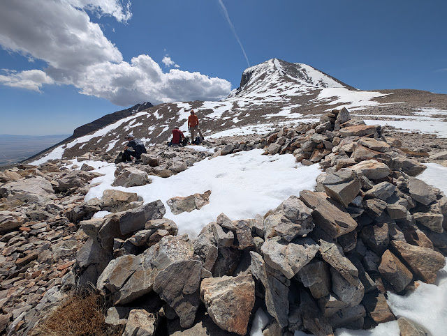
The big ridge had the wind shelters still full of snow.

And snow was the theme the rest of the way up. Although there were rocky patches, most of the way up was in the snow. 

In some places, the snow was easier to traverse than the rock.

I saw several of these Hemiptera, or true bugs.

The first time I go up a big peak each year is always the hardest. For this trip, I took 10 steps and then paused and took a couple breaths and repeated. 

For a short while I was even above Desert Boy. We could already see a long way off.

And then we were almost to the top!

We found the faster members of our group hanging out. This included Desert Girl, Desert Boy, and my nephew.

The view to the south was gorgeous, looking down into the North Fork of Baker Creek, Baker Peak, Pyramid Peak, Mt. Washington, and the Highland Ridge.

My daughter and nephew walked with me along the summit ridge towards Doso Doyabi, past the wind shelters and old heliotrope stations. These were used to help map the 39th parallel. You can read much more in the bood Geodesy: the transcontinental triangulation and the American arc of the parallel," 1900, US Coast and Geodetic Survey. I did not read it, but I did check that it's on Google Books at: https://books.google.com/books?id=--MNAQAAMAAJ. On page 334, it shows the measurements from Wheeler Peak to Tushar Mountain (near Beaver, UT), Mt. Nebo (near Nephi, UT), Ibapah Peak (near Callao, UT), and White Pine Peak (lost in NV).
p.s. You can learn more about Heliotropes on Wikipedia, including that someone using one could be called a "flasher."

Here they are, with Doso Doyabi obviously lower in the background.

The views were spectacular all around. Here's the ridge we had just climbed, with Stella and Teresa Lakes looking like little ponds in the right-center part of the photo.

As the clouds built, we gathered for a group photo.

We signed our names in the register, and then it was time to head down, with microspikes on.

We gave sliding down a try. It worked better on a jacket, as the snow was quite wet.

We had to be careful not to veer to the left, or we'd have a long hike into Spring Valley.

Remember how I said at the beginning that a later start might have a drawback? This was it. We found the snow was now very soft, and the postholing was awful. There were tears. 

But we did it! What a day.
This was one of the harder times for me to climb the peak, not only because my body wasn't so acclimated, but also because so much snow made it rather tough. I was so proud of my nephew, doing one of the hardest hikes of his life (so far). 

Wednesday, July 12, 2023

Snowy Great Basin National Park Hikes in June


Near mid-June 2023, the Wheeler Peak Scenic Drive opened. Most years it opens before Memorial Day weekend (last weekend in May), but this year there was so much snow it opened later. Desert Boy and I decided to go for a hike on the Alpine Lakes trail. Even at the trailhead, there was so much snow!

We didn't think to wear microspikes/exospikes/Yaktrax. Desert Boy fell down several times. I had a hiking pole and that helped me stay up.

When we got out of the trees more, we found patches where the snow had melted. But overall, we estimated that about 80% of the trail was covered with snow!

The orange blazes on the trees helped us know where the trail was.

Close to the lake we arrived at the sign showing the trail up to Wheeler Peak. That definitely was not in the plans for us that day! We could see plenty of snow ahead just on the way to Stella Lake.

To my surprise, as we approached the lake, I saw a lot of open water.

The lake wasn't entirely snow and ice free, though. We went to the corner with the most ice and snapped a selfie.


Desert Boy wasn't interested in a swim for some reason.

Some of the snow had a pinkish tinge to it, an indication that watermelon algae was present. As the saying goes, "Don't eat the pink snow!" Okay, maybe it's a different color that the saying refers to. But it's still not a good idea to eat the pink snow, it may cause some digestive troubles.

I was just slightly enamored with the lake and had to take one more photo from this vantage point.

As we walked around the lake, I spotted the viewing bench in the water. Desert Boy gamely jumped up on it for this humorous shot.

Desert Boy was wearing some new boots and was getting a blister. He found a tiny patch of ground and applied a bandaid.

The trail between Stella and Teresa Lakes was hard to follow, and we got lost for a bit.

But then we found our way, and soon were seeing Teresa Lake!

The lake was really full.

I was intrigued by the ice layer near the lake's edge. 

Desert Boy was trying to kick off an "iceberg" and managed to plunge his foot into the lake.

He posed on another water-logged bench.

As we left the lake, we found some deep snow. We met another hiker coming back from the Bristlecone Trail, who had turned around despite having microspikes because he felt it was too dangerous. 

This twisted tree is along the trail back to the parking lot, and looks extra cool surrounded by snow.

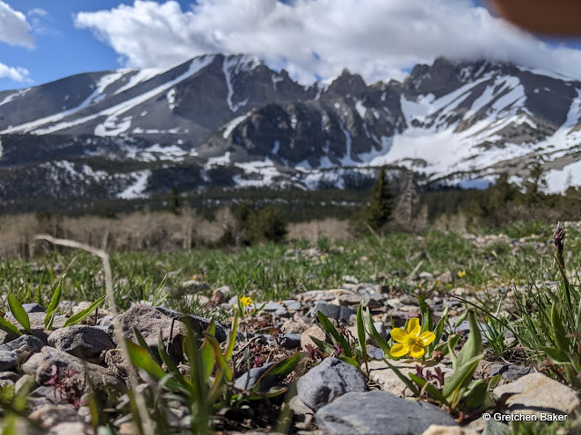
I was delighted when Desert Boy decided he liked hiking and wanted to go on another hike, up Bald Mountain. We started from the Summit trailhead. We did not find many flowers, despite it being the second part of June. A few snow buttercups lent a pop of color to the landscape. At this point, the clouds were just grazing the tops of the mountains.

This might be a golden mantled ground squirrel. It was not very afraid of us.

As we headed up Bald Mountain, we encountered lots of sun cups, or patterns in the snow that had melted out in roughly the shape of cups.

In quite a few of them, we found this bug, which we've seen other times on the hike up to Wheeler Peak.

To my surprise, we also saw a bunch of grasshoppers.

It was a windy day, and as we climbed higher, the wind got stronger. The clouds got lower. We decided it was time to turn around.

It was a lovely morning in beautiful scenery.

The aspen were just starting to leaf out. You can see which way the wind blows. 

The top of the mountain is missing!

It's fun seeing everything with more snow on it than usual. 
At the time of this posting, mid-July, there is still a fair bit of snow above 10,000 feet. It's interesting to see how different things look this year, including plants flowering much later, and stream and lake levels higher than usual.
Related Posts Plugin for WordPress, Blogger...

blogger templates