We were headed home from Las Vegas, a five-hour prospect, and the sun was setting quickly. We had to make a decision: drive all the way home or spend one more night out? The plan had been to camp one more night (night five), but being so close to home, we could also feel the pull. When I thought about driving so far in the dark, though, with lots of animals along the road, I decided we would stay one more night. That way we would have time to explore a little more. And I'm all about exploration.
I started with the beautiful Joshua tree forest along Highway 93 west of Caliente. This isn't a forest like you see in the Eastern United States or in the Pacific Northwest or the Rocky Mountains. A Joshua tree forest is spectacular in its own way.
The setting sun really lit up these trees. Then I noticed two hawks talking to each other from the tops of two trees. I went a little closer to get a better look and found they were Swainson's hawks. These hawks winter in Argentina and are now back! Hello!
The flowers on the Joshua tree come in big terminal clumps.
The individual flowers themselves might not be so showy, but altogether they make for an impressive display.
We had to decide where to camp. We had several options: trailheads for the Silver State OHV trail, Kershaw-Ryan State Park, or Cathedral Gorge State Park. We ended up choosing Kershaw-Ryan, as I had never been there and it was only two miles from Caliente. We pulled into the 15-site campground and selected a site. The kids put up the tent all by themselves while I made their meal of choice: top ramen. Yep, we were living it up!
The very nice ranger stopped by and gave us a brochure and told us about the pay showers (8 minutes for 50 cents) and the firewood. We availed ourselves of both, then went to bed.
The next morning was chilly, so I started a fire and roused the kids to eat some hashbrowns. Yum!
I got just a little bit of attitude.
We wanted to get home by lunch so we could see my husband and have the afternoon to unpack, so we packed up and headed further into the park. We were amazed at what we found. A small wading pool was near the end of the road. Since it was March, it didn't have water in it, but we could imagine how much fun it would be in summer.
We also found a playground, which the kids loved.
We decided to take the Canyon overlook trail, about 1.4 miles long. But since we didn't have much time, I told the kids we were going on a trail run. They were good sports and started running.
The trail was great, with nice views.
And benches for resting and goofing around.
We kept climbing higher, getting a view of more of the park.
I wondered what was up the side canyons. Although the principal vegetation was sagebrush and everything seemed quite dry, these canyons are subject to flash floods. In fact, nearly all the park facilities were wiped out by two back-to-back flash floods in 1984, and it took a long time for the state to appropriate money to rebuild.
The canyon was originally developed in 1873 by Samuel and Hannah Kershaw, who called their ranch Meadow Valley Wash Ranch. In 1904 they sold it to rancher James Ryan, who then donated it to the state in 1926 as a park. The Civilian Conservation Corps developed facilities in 1934, and it became a state park in 1935. Although in some ways you feel like you're going back in time in the park, the frequent trains (we heard about ten during the night) remind you that progress is chugging along.
Leaves were just appearing on some of the trees.
When we finished the trail run (which the kids rocked!), they checked out the fish pond.
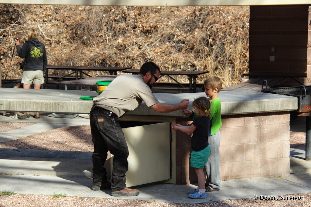
The ranger let them feed the fish, which they loved.
I'm looking forward to visiting again in the summer to check out all the rose bushes and for the kids to take a dip in the wading pool. This is truly an oasis, and the bird life is terrific. Kershaw-Ryan isn't far off the beaten path and definitely worth a stop. It was a wonderful way to end our fun spring break.
Monday, April 13, 2015
Sunday, April 12, 2015
Red Rock Canyon - Spring Break 2015
After Valley of Fire and visiting friends at Lake Mead, we headed to the Red Rock Rendezvous, a climbing-oriented weekend at Red Rock Canyon sponsored by Mountain Gear. The event sold out, so we were expecting a big crowd at the campground at Spring Mountain State Park, and we found it. Someone commented on how many of the tents looked the same, and it's true, they were remarkably similar! I guess climbers think alike.
My friend Randi joined us, and the next day we headed off early for a climbing clinic while my brother Ed watched the kids (thanks, Ed!). It's been awhile since I've climbed, so I felt really rusty. Nevertheless, I was ready to get on rope and climb some rock! I really appreciated Randi for talking me into attending.
Climbing instilled some fear in me, but also reminded me why I like. It feels really good to conquer a slab of rock.
Next it was Randi's turn, and she did a fine job of getting reacquainted. She's done some cool climbs, including a 16-pitch one in Yosemite that I'd love to do someday. It took her and her climbing partner 15 hours to do it. It turned out that one of our instructors held the speed record for that climb: 52 minutes. Whoa!
Here's Randi before she disappears around the corner.
It seemed like the right spot for a selfie!
We did a couple more climbs and then headed back to the parking lot. It took awhile to get back to camp, and when we did we found Ed relaxing in the shade by himself near the tent.
"Where are the kids?" I asked.
"Oh, they're playing in the creek." He pointed in the general direction, and I couldn't see them at all.
Um, should I be worried? Was I a helicopter mom or just reasonably cautious? I eventually went over to take a look.
Sure, enough, they were down in the ravine, happy as could be, playing in the creek that was at most a couple inches deep. They had had a great time with their uncle.
It was getting hotter, so we decided to take a walk and see if we couldn't find a swimming hole. Google maps showed a nice body of water nearby. Soon we found it.
But we also found out no swimming is allowed, as it's the home to the endangered Pahrump Poolfish (which used to live near Pahrump, but all the springs there went dry).
So we went back to the creek, where we had a good time.
The next morning we went climbing with the kids (something I managed not to get any photos of!), and that was fun until it got hot. So we wrapped it up and Randi headed home. We let the kids choose where to go for a late lunch, and they chose Indian food. I think I've trained my kids right! It was delicious.
Then it was one more activity before heading towards home: bowling.
Wow, it's been awhile since I've bowled. And bowling after rock climbing isn't exactly the best idea. But the kids had a fantastic time and it was air-conditioned, so it was good all around.
(The kids have decided it's really fun to stick out their tongues for photos.)Then it was time to head home. Except I got tired, so we spent one more night out...
Thursday, April 9, 2015
Lake Mead National Recreation Area - Spring Break 2015
After visiting Valley of Fire, we headed to nearby Lake Mead National Recreation Area. We just had a few hours to get a taste of it before we met friends. So we ate a picnic lunch by Rogers Spring and then went down to Echo Bay so we could see the lake.
We spotted a road runner, and even the kids were excited to see this neat bird.
Echo Bay was really interesting. It used to be extremely busy, with a restaurant, lodge, convenience store, RV park, campground, and more. Then the lake levels started dropping. And no longer could you motor in and just saunter up to the restaurant or lodge. It was a longish walk in sweltering summer temperatures. Visitation started dropping. And the lake levels kept dropping, so the restaurant (below) and lodge closed.
Before long the marina closed. New islands appeared.
Fuel was no longer offered, although people could still launch boats at the boat launch, over a mile from the developed areas.
In the photo below you can see the old boat launch in the center of the photo, far back, and the new one on the right.
So Echo Bay, although still larger than where I live, almost seemed like a ghost town. It was a little surreal. Okay, a lot surreal. I kept looking around, wondering where everyone was, imagining how it used to be. In the 1980s, this place was rocking. The reservoir was at capacity. Probably very few people imagined that the lake levels would drop a little bit, and almost none to the extent that it has.
I still can't wrap my head around it all.
We were also fascinated by the 18-inch high fences along the road. We figured out they were to keep the tortoises from getting squashed. They looked ever so funny, though.
Further down the road we turned into Callville Bay. It's faring better than Echo Bay. Boat rentals are still available--and sure would be fun! Nevertheless, the telltale lake rings and increased distance from the developed areas made it seem like a place past its prime.
Next we went to Boulder Beach, where we swam a little. We were hesitant because there was green algae in the water, but hoped that if so many other people were swimming, it would be okay. When we left, I got a photo of the Southern Nevada Water Authority straw into the lake. This is where Las Vegas' drinking water comes from, a place called Saddle Island that is now a peninsula.
Soon after we met our friends, took showers, and had a nice visit. An unfortunately I didn't take any photos! It was a very nice short trip to Lake Mead, and we'd sure like to go back and explore more.
Next up: Red Rock Canyon
Monday, April 6, 2015
Valley of Fire State Park
For spring break I had a bad travel itch, so we headed south and after dentist visits went to Valley of Fire State Park.
Our friends had saved us a campsite that was super awesome (thank you so much!), and after visiting and catching up a bit, we decided to go tackle a hike at Mouse's Tank.
It's a popular trail, but late in the afternoon there weren't so many people on it and it was cooler.
It didn't take long to get to Mouse's Tank, and we went and got a close look at a pool.
Then we began a really fun game of hide'n seek. We found all sorts of little alcoves.
I had to scramble into some little caves to check them out too.
We found a cool ramp that ascended between two cliffs.
We started to get hungry and headed back to the campsite in the evening glow.
The night was gorgeous, and we went for a little hike around the campground. Then we settled in for an evening under the stars, the rainfly off.
We had a leisurely morning (meaning the kids slept in until 6:30!), then got ready to go hiking. Arch Rock was backlit nicely with the morning light.
Then it was time to run up to the petroglyphs. The kids charged off.
And I got distracted by this bird.
When I turned around, they had already made it to the platform. It's a good leg burner if you run up all the steps!
Across the road we took the trail to the petrified wood.
The mineralization is so beautiful. And it's kind of neat to think about how a forest used to be in this area. Nowadays you have to look far to find a tree!
The color of the rocks was breathtaking, and I took way too many photos. (As you can tell by this rather longish post!)
Next we went to the nice visitor center and then up the road to Rainbow Point, where the scenery again was breathtaking.
I wanted to go see The Wave, which is featured on the cover of the Valley of Fire brochure and has been widely photographed. Along the way the beautiful cacti caught our attention, and the kids literally stopped to smell the flowers.
The way to the Wave was gorgeous. The rock layers undulate and the colors change.
Before long we were approaching The Wave. Or what I guessed was the Wave, since there were a lot of people taking photos.
It looks something like this. It's cool, but I saw many rocks that I thought were more beautiful! I guess it just goes to show that what one person likes isn't necessarily going to be everyone else's favorite.
The kids thought the Wave was kind of boring and they were hot, so they found a cool place to rest.
Eventually I convinced them we should return, and we found some other pretty things along the way.
When we got back to the vehicle, the kids declared they were done with hiking. So we went back to the campsite and had a picnic lunch. The pavilions over the picnic tables were wonderful for providing shade. Before long, the kids wanted to go scamper around the rocks by the campsite. We found a cool cave at the very top and took some entertainment to enjoy there.
The views were great. Then the kids spotted other kids and the next couple hours were spent playing and exploring.

After a trip to Overton to see the Lost City Museum and get some firewood and marshmallows, we returned for a spaghetti dinner. But I had to stop on the way back in the park and enjoy the golden hour. These globemallow were gorgeous.
This little rodent really wanted a handout.
A photographer pointed out a helicopter that had landed on top of the rocks. He said a bride and groom had hopped out.
The light was fading when we got back to the campsite, but it was still beautiful.
After dinner we took a walk across the road and watched the stars come out and the campfires light up the rocks.
The next morning we packed up and I took a few more photos.
Then it was time for one more hike, the White Rocks loop.

Guess what? The rocks were white. Ha, ha.
The kids were a bit grumpy, so I challenged them to not touch the ground. They liked that.
And before long we were leaving Nevada's oldest and largest state park and heading on to our next adventure of spring break.
To be continued...
Subscribe to:
Posts (Atom)