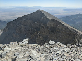
The highest peak around, Wheeler Peak, at 13, 063 feet, was calling my name. I didn't want to spend a whole day going up it, so I decided to do a trail run up it to make it faster. That meant an early start, a light pack, and few breaks.
My niece Kayli said she was interested, and since she's on her school's cross-country team, I knew she could do it, even though she hadn't been up the peak before.
We were the first ones to the trailhead at about 6:30 am, which surprised me, as that wasn't super early. We started off at a slow jog, interspersed with fast walking, as even at 10,000 feet, the air was a little thin. As we went higher, we did a lot more walking than jogging.
When we got to the ridge, we took our first break at one of the wind shelters. It was nice to sit down for a few minutes and have a quick snack.
Then we headed up to the summit, pausing here and there for what I call breathing breaks. We crossed a couple snow patches. We didn't see many flowers, probably because it has been so dry. When we got to the top, we signed into the full register and then took some photos. I didn't want to rush the top, so we decided to spend 30 minutes up there.
I'm not good at staying still, so I took Kayli down the summit ridge so we could get a good look at Doso Doyabi, at 12, 776 feet. It has an impressive face.
The most common flower we saw were sky pilot (Polemonium viscosum). They were in the best shape on the southeast side. As they mature, they start smelling like skunk, hence another common name for them: skunkweed.
We descended a bit so I could get a good view of the Wheeler cirque rock glacier. The lobes in the upper part of the rock glacier indicate movement, or where there is still ice under the rock. The section farther downhill, where the rock glacier gets narrower, does not appear to have ice under it anymore.
We found a survey marker from the U.S. Coast and Geodetic Survey from 1944. This one was No. 5.
We also found No. 4. Now I'm wondering if Numbers 1, 2, and 3 are also on the summit. I'll have to look next time!
The large rock shelters on Wheeler Peak started as heliograph stations. They were used during two winters(!) to help map the 39th parallel west of the 100th meridian in the 1880s. Other nearby peaks with heliograph stations on them include Ibapah Peak in the Deep Creek Range to the north, Mt. Nebo in the Wasatch Range to the east, and Troy Peak to the west.
Often in July, a hiker can see lots of Parry's Primrose near the top of the peak. This year, though, I only saw two that were blooming. We might have been a bit early, but it just seems so dry.
We found some gray-crowned rosy finches on the snow. They eat the little insects that get trapped.
As we headed down, we found we were able to jog more than we expected.
We also started meeting people coming up. About 15 people were headed up. We had fun chatting with some of them. The temperatures were also heading up, so we were glad we were going down. We didn't need to carry as much water due to the cooler temps.
Kayli got in quite a good workout for cross country!
We were surprised how fast it was to descend. I always considered the descent fairly difficult, but maybe all the trail running I've done over the past couple of years has helped me to reframe my thinking. We didn't break any Strava records by any means, but did get back to the vehicle by about 10:20. That meant we still had the rest of the day for more adventures!


No comments:
Post a Comment
Hi, I love to read your comments! I've recently decided to turn off word verification to make it easier to leave comments, but in doing so, I'm only accepting registered users to avoid spam. You can also leave comments on the Desert Survivor Facebook page. Thanks!